|
search place name
|
||
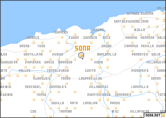
Soña (Cantabria, Spain)Soña is a town in the Cantabria region of Spain. An overview map of the region around Soña is displayed below.
regional and 3d topo map of Soña, Spain ::
Soña airports ::
The nearest airport is SDR - Santander, located 15.4 km east of Soña.
Other airports nearby include BIO - Bilbao (88.8 km east), VIT - Vitoria (117.7 km south east), VLL - Valladolid (199.0 km south), Nearby towns ::
La Iglesia (1.3km west) //
Rumoroso (1.3km east) //
Ramera (1.3km west) //
Posadillo (1.3km west) //
Bárcena de Cudón (1.9km north) //
Mar (2.3km north west) //
Barrio Obrero (2.7km west) //
Vioño (3.3km south east) //
Barreda (3.3km south west) //
Zurita (3.9km south) //
Requejada (3.3km north west) //
Cudón (3.9km north) //
Gormazo (3.9km north) //
Sierrapando (4.6km south west) //
Cortiguera (4.6km north west) //
Viveda (4.0km west) //
Barcenilla (4.0km east) //
Quijano (4.4km south east) //
Renedo (4.4km south east) //
Las Presillas (5.7km south) //
Oruña (4.4km north east) //
Cuchia (5.7km north) //
Miengo (5.7km north) //
Torrelavega (5.5km south west) //
Campuzano (5.5km south west) //
Tanos (6.2km south west) //
Carandía (6.2km south east) //
Mogro (6.2km north east) //
La Calzada (5.5km north east) //
[all distances 'as the bird flies' and approximate] 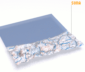 Places with similar names to Soña, Spain ::
Disclaimer :: Information on this page comes without warranty of any kind |
||
|
Where is Soña? Elevation and coordinates ::
Latitude (lat): 43°23'0"N Longitude (lon): 4°0'0"W
Elevation (approx.): 27m (map arrows pan, magnifying glasses zoom) |
||
|
Visiting Soña? Hotel/Accommodation ::
Book a hotel in Soña Travel Guide ::
Buy a travel guide for Spain rental cars ::
car rental offers GPS waypoint ::
download a GPX waypoint (PoI) of Soña for your GPS receiver
|
||