|
search place name
|
||
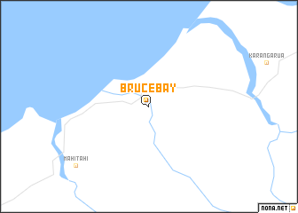
Bruce Bay (Akaroa, New Zealand)Bruce Bay is a town in the Akaroa region of New Zealand. An overview map of the region around Bruce Bay is displayed below.
regional and 3d topo map of Bruce Bay, New Zealand ::
Bruce Bay airports ::
The nearest airport is GTN - Mount Cook, located 41.5 km south east of Bruce Bay.
Other airports nearby include MON - Glentanner (50.7 km south east), WKA - Wanaka (131.3 km south), HKK - Hokitika (143.4 km north east), TIU - Timaru (147.4 km south east), Nearby towns ::
[all distances 'as the bird flies' and approximate]  Places with similar names to Bruce Bay, New Zealand ::
// Borşa-Baia (RO)
// Baraseba (ZA)
// Barzāb (IR)
// Berāsb (IR)
// Bresibi (NG)
// Berseba (NA)
// Borisubi (PG)
// Biʼr aş Şabāḩ (SY)
// Barrys Bay (CA)
// Barrys Bay (NZ)
Disclaimer :: Information on this page comes without warranty of any kind |
||
|
Where is Bruce Bay? Elevation and coordinates ::
Latitude (lat): 43°35'0"S Longitude (lon): 169°41'0"E
Elevation (approx.): 17m (map arrows pan, magnifying glasses zoom) |
||
|
Visiting Bruce Bay? Hotel/Accommodation ::
Book a hotel in Bruce Bay Travel Guide ::
Buy a travel guide for New Zealand rental cars ::
car rental offers GPS waypoint ::
download a GPX waypoint (PoI) of Bruce Bay for your GPS receiver
|
||