|
search place name
|
||
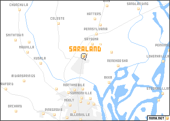
Saraland (Alabama, United States - USA)Saraland is a town in the Alabama region of United States - USA. An overview map of the region around Saraland is displayed below.
regional and 3d topo map of Saraland, United States - USA ::
Saraland airports ::
The nearest airport is BFM - Mobile Downtown, located 21.5 km south of Saraland.
Other airports nearby include MOB - Mobile Rgnl (21.9 km south west), NPA - Pensacola Nas (88.8 km south east), PNS - Pensacola Rgnl (93.1 km south east), BIX - Biloxi Keesler Afb (93.7 km south west), Nearby towns ::
Mackies (1.4km north) //
Satsuma (3.9km north) //
Cox Beach (4.5km north east) //
Liveoak Landing (5.4km east) //
Chickasaw (6.3km south) //
Pennsylvania (6.2km north) //
North Mobile (6.9km south) //
Akka (6.6km south east) //
Nenemoosha (6.4km east) //
Whistler (7.8km south west) //
Summerville (8.4km south) //
Sibert (8.5km south) //
Creola (8.4km north) //
Eight Mile (8.3km south west) //
Celeste (9.6km north west) //
[all distances 'as the bird flies' and approximate]  Places with similar names to Saraland, United States - USA ::
// Sørland (NO)
// Sørland (NO)
// Scîrlenţea (RO)
// Saré Landia (SN)
// Sūrlandai (PK)
// Sara Linda (VE)
// Sarlande (FR)
// Serrolândia (BR)
// Sierra Linda (US)
// Saarlanti (FI)
Disclaimer :: Information on this page comes without warranty of any kind |
||
|
Where is Saraland? Elevation and coordinates ::
Latitude (lat): 30°49'14"N Longitude (lon): 88°4'14"W
Elevation (approx.): 9m (map arrows pan, magnifying glasses zoom) |
||
|
Visiting Saraland? Hotel/Accommodation ::
Book a hotel in Saraland Travel Guide ::
rental cars ::
car rental offers GPS waypoint ::
download a GPX waypoint (PoI) of Saraland for your GPS receiver
|
||