|
search place name
|
||
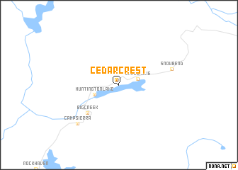
Cedar Crest (California, United States - USA)Cedar Crest is a town in the California region of United States - USA. An overview map of the region around Cedar Crest is displayed below.
regional and 3d topo map of Cedar Crest, United States - USA ::
Cedar Crest airports ::
The nearest airport is FAT - Fresno Yosemite Intl, located 69.5 km south west of Cedar Crest.
Other airports nearby include MER - Merced Castle (122.2 km west), MOD - Modesto City Co Harry Sham (160.9 km west), BFL - Bakersfield Meadows Fld (201.4 km south), RIU - Rancho Murieta (216.8 km north west), Nearby towns ::
Lakeshore (2.5km east) //
Huntington Lake (3.4km south west) //
Big Creek (6.0km south west) //
Snow Bend (7.1km east) //
Camp Sierra (8.0km south west) //
[all distances 'as the bird flies' and approximate] 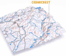 Places with similar names to Cedar Crest, United States - USA ::
// Staryye Kresty (RU)
// Cedar Crest (US)
// Cedar Crest (US)
// Stari Krst (BA)
// Cedarcrest (US)
// Cedar Crest (US)
// Cedar Crest (US)
// Cedarcrest (US)
// Cedar Crest (US)
// Cedar Crest (US)
Disclaimer :: Information on this page comes without warranty of any kind |
||
|
Where is Cedar Crest? Elevation and coordinates ::
Latitude (lat): 37°14'42"N Longitude (lon): 119°12'1"W
Elevation (approx.): 2165m (map arrows pan, magnifying glasses zoom) |
||
|
Visiting Cedar Crest? Hotel/Accommodation ::
Book a hotel in Cedar Crest Travel Guide ::
rental cars ::
car rental offers GPS waypoint ::
download a GPX waypoint (PoI) of Cedar Crest for your GPS receiver
|
||