|
search place name
|
||
Cedar Crest (New Mexico, United States - USA)Cedar Crest is a town in the New Mexico region of United States - USA. An overview map of the region around Cedar Crest is displayed below.
regional and 3d topo map of Cedar Crest, United States - USA ::

Cedar Crest airports ::
The nearest airport is ABQ - Albuquerque Intl Sunport (Kirtland Afb), located 22.9 km west of Cedar Crest.
Other airports nearby include TCS - Truth Or Consequences Muni (223.4 km south), ROW - Roswell Intl Air Center (262.6 km south east), Nearby towns ::
San Antonio (0.8km south west) //
Forest Park (1.0km north) //
Rincon (1.3km north east) //
Casa Loma (1.2km west) //
Zamora (1.7km east) //
Primera Agua (2.7km south) //
Canoncito (3.3km north) //
Tijeras (3.3km south west) //
El Tablazon (3.0km east) //
El Refugio (3.3km east) //
Los Pinos (5.2km east) //
Dennis Chaves Estates (5.3km east) //
Sandia Park (6.7km north) //
San Antonito (6.6km north) //
Sedillo (7.1km east) //
Sandia Knolls (8.4km north east) //
[all distances 'as the bird flies' and approximate] 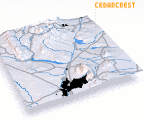 Places with similar names to Cedar Crest, United States - USA ::
// Staryye Kresty (RU)
// Cedar Crest (US)
// Cedar Crest (US)
// Cedar Crest (US)
// Stari Krst (BA)
// Cedarcrest (US)
// Cedar Crest (US)
// Cedarcrest (US)
// Cedar Crest (US)
// Cedar Crest (US)
Disclaimer :: Information on this page comes without warranty of any kind |
||
|
Where is Cedar Crest? Elevation and coordinates ::
Latitude (lat): 35°6'27"N Longitude (lon): 106°22'20"W
Elevation (approx.): 2035m (map arrows pan, magnifying glasses zoom) |
||
|
Visiting Cedar Crest? Hotel/Accommodation ::
Book a hotel in Cedar Crest Travel Guide ::
rental cars ::
car rental offers GPS waypoint ::
download a GPX waypoint (PoI) of Cedar Crest for your GPS receiver
|
||