|
search place name
|
||
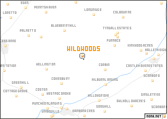
Wildwoods (Maryland, United States - USA)Wildwoods is a town in the Maryland region of United States - USA. An overview map of the region around Wildwoods is displayed below.
regional and 3d topo map of Wildwoods, United States - USA ::
Wildwoods airports ::
The nearest airport is SBY - Salisbury Ocean City Wicomico Rgnl, located 18.4 km north of Wildwoods.
Other airports nearby include NHK - Patuxent River Nas (77.8 km west), DOV - Dover Afb (106.1 km north), WWD - Wildwood Cape May Co (107.4 km north east), ADW - Camp Springs Andrews Afb (Washington Dc Naf) (135.9 km north west), Nearby towns ::
Whiteburg (1.1km north) //
Corbin (4.4km south east) //
Cokesbury (6.7km south west) //
Milburn Landing (6.9km south east) //
Furnace (6.3km north east) //
Blueberry Hill (7.3km north west) //
Wellington (6.9km west) //
Nassawango Hills (7.9km north east) //
Rolling Hills (7.9km north east) //
Tyndall Estates (8.5km north east) //
West Pocomoke (9.7km south west) //
[all distances 'as the bird flies' and approximate]  Places with similar names to Wildwoods, United States - USA ::
Disclaimer :: Information on this page comes without warranty of any kind |
||
|
Where is Wildwoods? Elevation and coordinates ::
Latitude (lat): 38°10'32"N Longitude (lon): 75°32'5"W
Elevation (approx.): 13m (map arrows pan, magnifying glasses zoom) |
||
|
Visiting Wildwoods? Hotel/Accommodation ::
Book a hotel in Wildwoods Travel Guide ::
rental cars ::
car rental offers GPS waypoint ::
download a GPX waypoint (PoI) of Wildwoods for your GPS receiver
|
||