|
search place name
|
||
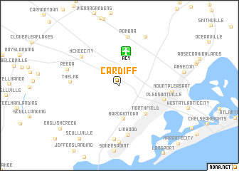
Cardiff (New Jersey, United States - USA)Cardiff is a town in the New Jersey region of United States - USA. An overview map of the region around Cardiff is displayed below.
regional and 3d topo map of Cardiff, United States - USA ::
Cardiff airports ::
The nearest airport is ACY - Atlantic City Intl, located 5.4 km north of Cardiff.
Other airports nearby include MIV - Millville Muni (42.0 km west), WWD - Wildwood Cape May Co (52.5 km south west), WRI - Wrightstown Mc Guire Afb (67.2 km north), NEL - Lakehurst Naes (72.1 km north), Nearby towns ::
Bargaintown (5.3km south) //
Northfield (5.4km south east) //
Pleasantville (5.9km south east) //
McKee City (6.4km north west) //
Thelma (5.9km west) //
Pomona (7.7km north) //
Linwood (7.9km south) //
Mount Pleasant (6.4km east) //
Steelmanville (8.5km south) //
Reega (6.8km west) //
Pinehurst (8.3km north east) //
Scullville (9.6km south west) //
[all distances 'as the bird flies' and approximate] 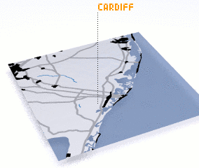 Places with similar names to Cardiff, United States - USA ::
Disclaimer :: Information on this page comes without warranty of any kind |
||
|
Where is Cardiff? Elevation and coordinates ::
Latitude (lat): 39°24'36"N Longitude (lon): 74°35'15"W
Elevation (approx.): 13m (map arrows pan, magnifying glasses zoom) |
||
|
Visiting Cardiff? Hotel/Accommodation ::
Book a hotel in Cardiff Travel Guide ::
rental cars ::
car rental offers GPS waypoint ::
download a GPX waypoint (PoI) of Cardiff for your GPS receiver
|
||