|
search place name
|
||
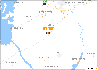
Starr (South Carolina, United States - USA)Starr is a town in the South Carolina region of United States - USA. An overview map of the region around Starr is displayed below.
regional and 3d topo map of Starr, United States - USA ::
Starr airports ::
The nearest airport is AND - Andersen Anderson Rgnl, located 13.1 km north of Starr.
Other airports nearby include AGS - Bush Field Augusta Rgnl At Bush Fld (130.6 km south east), CAE - Colombia Columbia Metropolitan (153.3 km east), MGE - Marietta Dobbins Arb (Atlanta Nas) (175.5 km west), ATL - Hartsfield Jackson Atlanta Intl (179.9 km south west), Nearby towns ::
Deans (2.9km north) //
Flat Rock (6.6km north east) //
Chambert Forest (7.4km north) //
Mountain Creek (7.7km north) //
Iva (8.4km south) //
Gluck (8.8km north) //
Allendale (8.2km north west) //
Meadow Fields (8.5km north east) //
Fernwood (9.6km north east) //
Clover Hill (9.6km north east) //
[all distances 'as the bird flies' and approximate] 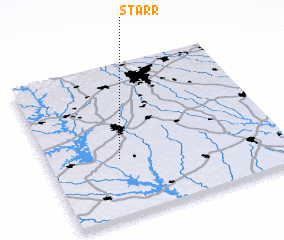 Places with similar names to Starr, United States - USA ::
Disclaimer :: Information on this page comes without warranty of any kind |
||
|
Where is Starr? Elevation and coordinates ::
Latitude (lat): 34°22'37"N Longitude (lon): 82°41'45"W
Elevation (approx.): 235m (map arrows pan, magnifying glasses zoom) |
||
|
Visiting Starr? Hotel/Accommodation ::
Book a hotel in Starr Travel Guide ::
rental cars ::
car rental offers GPS waypoint ::
download a GPX waypoint (PoI) of Starr for your GPS receiver
|
||