|
search place name
|
||
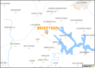
Bakertown (Tennessee, United States - USA)Bakertown is a town in the Tennessee region of United States - USA. An overview map of the region around Bakertown is displayed below.
regional and 3d topo map of Bakertown, United States - USA ::
Bakertown airports ::
The nearest airport is HUA - Redstone Aaf, located 72.0 km south west of Bakertown.
Other airports nearby include BNA - Nashville Intl (101.1 km north), CHA - Chattanooga Lovell Fld (105.6 km east), HOP - Hopkinsville Campbell Aaf (188.5 km north west), ANB - Anniston Metro (190.3 km south), Nearby towns ::
Hickory Hill (1.5km west) //
Ridgeville (3.2km north east) //
Pleasant Hill (4.1km north) //
Lois (4.3km south west) //
Lynchburg (4.8km north west) //
Beech Hill (5.2km south east) //
Marble Hill (6.2km south) //
Brownington (6.0km east) //
Turkey Creek (6.9km north east) //
Raysville (8.1km north) //
Countyline (8.0km north west) //
Gattistown (8.2km south west) //
[all distances 'as the bird flies' and approximate]  Places with similar names to Bakertown, United States - USA ::
// Bou Kerdane (MA)
// Boukerdine (MA)
// Bacradan (PH)
// Bockarten (DE)
// Bockraden (DE)
// Bockraden (DE)
// Boca Raton (US)
// Bookertown (US)
// Bakertown (US)
// Bogurdany (RU)
Disclaimer :: Information on this page comes without warranty of any kind |
||
|
Where is Bakertown? Elevation and coordinates ::
Latitude (lat): 35°15'31"N Longitude (lon): 86°19'49"W
Elevation (approx.): 333m (map arrows pan, magnifying glasses zoom) |
||
|
Visiting Bakertown? Hotel/Accommodation ::
Book a hotel in Bakertown Travel Guide ::
rental cars ::
car rental offers GPS waypoint ::
download a GPX waypoint (PoI) of Bakertown for your GPS receiver
|
||