|
search place name
|
||
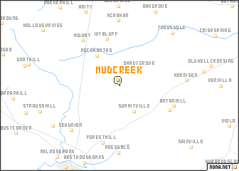
Mud Creek (Tennessee, United States - USA)Mud Creek is a town in the Tennessee region of United States - USA. An overview map of the region around Mud Creek is displayed below.
regional and 3d topo map of Mud Creek, United States - USA ::
Mud Creek airports ::
The nearest airport is BNA - Nashville Intl, located 84.0 km north west of Mud Creek.
Other airports nearby include CHA - Chattanooga Lovell Fld (96.3 km south east), HUA - Redstone Aaf (118.7 km south west), HOP - Hopkinsville Campbell Aaf (178.9 km north west), MGE - Marietta Dobbins Arb (Atlanta Nas) (231.4 km south east), Nearby towns ::
Shady Grove (3.7km north east) //
Summitville (4.4km south east) //
Pocahontas (5.5km north west) //
Ivy Bluff (7.4km north) //
Fountain Grove (7.4km south east) //
Bryan Mill (7.6km south east) //
Midway (8.4km north west) //
Forest Mill (9.1km south) //
New Union (9.3km south west) //
Trousdale (10.6km north east) //
[all distances 'as the bird flies' and approximate]  Places with similar names to Mud Creek, United States - USA ::
// Mud Creek (US)
// Muddy Creek (US)
// Muddy Creek (US)
// Mud Creek (US)
// Motukaraka (NZ)
// Meetkerke (BE)
// Meadow Creek (US)
// Meadow Creek (US)
// Mad Creek (US)
// Muddy Creek (AU)
Disclaimer :: Information on this page comes without warranty of any kind |
||
|
Where is Mud Creek? Elevation and coordinates ::
Latitude (lat): 35°35'44"N Longitude (lon): 86°0'48"W
Elevation (approx.): 332m (map arrows pan, magnifying glasses zoom) |
||
|
Visiting Mud Creek? Hotel/Accommodation ::
Book a hotel in Mud Creek Travel Guide ::
rental cars ::
car rental offers GPS waypoint ::
download a GPX waypoint (PoI) of Mud Creek for your GPS receiver
|
||