|
search place name
|
||
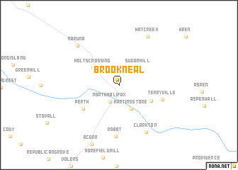
Brookneal (Virginia, United States - USA)Brookneal is a town in the Virginia region of United States - USA. An overview map of the region around Brookneal is displayed below.
regional and 3d topo map of Brookneal, United States - USA ::
Brookneal airports ::
The nearest airport is RDU - Raleigh-durham Raleigh Durham Intl, located 130.9 km south of Brookneal.
Other airports nearby include RIC - Richmond Intl (152.7 km east), INT - Winston-salem Smith Reynolds (153.0 km south west), POB - Fayetteville Pope Afb (208.6 km south), GSB - Goldsboro Seymour Johnson Afb (209.4 km south east), Nearby towns ::
North Halifax (2.8km south west) //
Sugar Hill (3.7km north east) //
Martins Store (4.0km south east) //
Holts Crossing (4.2km north west) //
Patrick Henry (4.8km south east) //
Perth (5.9km south west) //
Terryville (6.0km east) //
Rabat (8.1km south) //
Clarkton (8.2km south east) //
Hat Creek (8.4km north east) //
Naruna (8.1km north west) //
[all distances 'as the bird flies' and approximate] 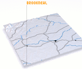 Places with similar names to Brookneal, United States - USA ::
// Brignole (IT)
// Brugnola (IT)
// Birkeneļi (LV)
// Bărăganul (RO)
// Bărcanele (RO)
// Borakanelo (ZA)
// Borakanelo (BW)
// Bracknell (AU)
// Brucknell (AU)
// Bracknell (GB)
Disclaimer :: Information on this page comes without warranty of any kind |
||
|
Where is Brookneal? Elevation and coordinates ::
Latitude (lat): 37°3'0"N Longitude (lon): 78°56'40"W
Elevation (approx.): 169m (map arrows pan, magnifying glasses zoom) |
||
|
Visiting Brookneal? Hotel/Accommodation ::
Book a hotel in Brookneal Travel Guide ::
rental cars ::
car rental offers GPS waypoint ::
download a GPX waypoint (PoI) of Brookneal for your GPS receiver
|
||