|
search place name
|
||
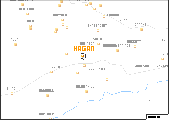
Hagan (Virginia, United States - USA)Hagan is a town in the Virginia region of United States - USA. An overview map of the region around Hagan is displayed below.
regional and 3d topo map of Hagan, United States - USA ::
Hagan airports ::
The nearest airport is TYS - Knoxville Mc Ghee Tyson, located 117.7 km south west of Hagan.
Other airports nearby include HKY - Hickory Rgnl (201.3 km south east), CHA - Chattanooga Lovell Fld (253.5 km south west), Nearby towns ::
Smiley (1.3km south) //
Sampson (2.6km north) //
Henegartown (3.2km south) //
Carrol Mill (3.8km south east) //
Martins Fork (3.4km north west) //
Smith (4.3km north east) //
Cedar Hill (6.0km south east) //
Wilson Hill (7.1km south) //
Three Point (7.0km north) //
Hubbard Springs (6.2km east) //
Boons Path (6.5km south west) //
Yancey (7.8km north west) //
Liggett (7.6km north west) //
Bardo (8.0km north west) //
Stanfill (8.3km north west) //
Pansy (8.7km north west) //
Mary Alice (9.7km north west) //
Cawood (10.3km north east) //
Edds Mill (10.3km south west) //
[all distances 'as the bird flies' and approximate] 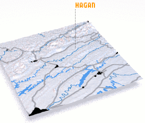 Places with similar names to Hagan, United States - USA ::
Disclaimer :: Information on this page comes without warranty of any kind |
||
|
Where is Hagan? Elevation and coordinates ::
Latitude (lat): 36°42'15"N Longitude (lon): 83°17'12"W
Elevation (approx.): 438m (map arrows pan, magnifying glasses zoom) |
||
|
Visiting Hagan? Hotel/Accommodation ::
Book a hotel in Hagan Travel Guide ::
rental cars ::
car rental offers GPS waypoint ::
download a GPX waypoint (PoI) of Hagan for your GPS receiver
|
||