|
search place name
|
||
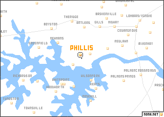
Phillis (Virginia, United States - USA)Phillis is a town in the Virginia region of United States - USA. An overview map of the region around Phillis is displayed below.
regional and 3d topo map of Phillis, United States - USA ::
Phillis airports ::
The nearest airport is RDU - Raleigh-durham Raleigh Durham Intl, located 90.9 km south west of Phillis.
Other airports nearby include RIC - Richmond Intl (134.0 km north east), GSB - Goldsboro Seymour Johnson Afb (144.3 km south), POB - Fayetteville Pope Afb (170.9 km south), PHF - Newport News Williamsburg Intl (173.5 km east), Nearby towns ::
Castle Heights (1.8km north east) //
Cusco Willa (2.2km south west) //
Norvello (2.5km north) //
Wilson Fork (5.2km south) //
Elamtown (5.2km north east) //
Newmans (5.7km north west) //
Presbyterian Point (6.6km south) //
Eppes Fork (6.7km south west) //
Antlers (7.2km north) //
Whits Point (7.0km south west) //
Keats (7.3km south) //
Gills (8.0km north east) //
The Ridge (8.8km north) //
Woodworth (8.9km south west) //
Boydton (8.8km north west) //
Midway (9.4km north east) //
[all distances 'as the bird flies' and approximate] 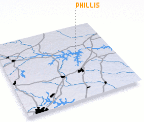 Places with similar names to Phillis, United States - USA ::
Disclaimer :: Information on this page comes without warranty of any kind |
||
|
Where is Phillis? Elevation and coordinates ::
Latitude (lat): 36°36'21"N Longitude (lon): 78°19'31"W
Elevation (approx.): 98m (map arrows pan, magnifying glasses zoom) |
||
|
Visiting Phillis? Hotel/Accommodation ::
Book a hotel in Phillis Travel Guide ::
rental cars ::
car rental offers GPS waypoint ::
download a GPX waypoint (PoI) of Phillis for your GPS receiver
|
||