|
search place name
|
||
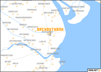
Ấp Châu Thanh (Sóc Trăng, Vietnam)Ấp Châu Thanh is a town in the Sóc Trăng region of Vietnam. An overview map of the region around Ấp Châu Thanh is displayed below.
regional and 3d topo map of Ấp Châu Thanh, Vietnam ::
Ấp Châu Thanh airports ::
The nearest airport is SGN - Ho Chi Minh City Tansonnhat Intl, located 157.9 km north of Ấp Châu Thanh.
Nearby towns ::
Lịch Hội Thượng (1.1km east) //
Ấp Ðầu Giồng (1.4km north west) //
Ấp Phố Dưới (1.5km south) //
Ấp Hắc Hợp (2.4km south) //
Ấp Nhà Việc (2.7km north east) //
Trùng Bình (3.2km south) //
Liêu Tú (4.2km south west) //
Trùng Bình (5.7km north) //
Bẳng Lẳng (5.8km south) //
Xóm Chệc (5.8km west) //
Ấp Sài Gòn (6.6km west) //
Xóm Luối (7.0km north) //
Ấp Sóc Dịch (7.1km west) //
Tà Liêu (7.2km south west) //
Xóm Mỹ Thạnh (7.5km south) //
Ấp Ngan Rô (7.7km north) //
Xóm Tú Diễm (7.8km north) //
Xóm Tra Teo (8.0km south west) //
Ấp Tổng Cang (8.0km west) //
Ấp Ô Ma (8.2km south west) //
Tường Ðại Hòa (8.6km south) //
Tà Mun (8.6km north) //
Bưng Cốc (8.8km north) //
Ngoài Vàm (8.8km north) //
[all distances 'as the bird flies' and approximate] 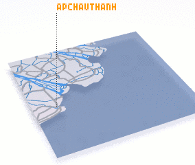 Places with similar names to Ấp Châu Thanh, Vietnam :: Disclaimer :: Information on this page comes without warranty of any kind |
||
|
Where is Ấp Châu Thanh? Elevation and coordinates ::
Latitude (lat): 9°28'37"N Longitude (lon): 106°9'36"E
Elevation (approx.): -2m (map arrows pan, magnifying glasses zoom) |
||
|
Visiting Ấp Châu Thanh? Hotel/Accommodation ::
Book a hotel in Ấp Châu Thanh Travel Guide ::
Buy a travel guide for Vietnam rental cars ::
car rental offers GPS waypoint ::
download a GPX waypoint (PoI) of Ấp Châu Thanh for your GPS receiver
|
||