|
search place name
|
||
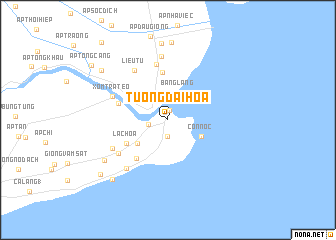
Tường Ðại Hòa (Vietnam)Tường Ðại Hòa is a town in Vietnam. An overview map of the region around Tường Ðại Hòa is displayed below.
regional and 3d topo map of Tường Ðại Hòa, Vietnam ::
Tường Ðại Hòa airports ::
The nearest airport is SGN - Ho Chi Minh City Tansonnhat Intl, located 165.7 km north of Tường Ðại Hòa.
Nearby towns ::
Xóm Mỹ Thạnh (1.1km north) //
Giống Phủ Yết (1.9km south) //
Xóm Sâm Pha (2.2km west) //
Bẳng Lẳng (3.2km north) //
Cồn Nóc (4.1km south east) //
Giồng Ông Tượng (4.2km south west) //
Lạc Hòa (5.2km south west) //
Trùng Bình (5.4km north) //
Ấp Âu Thọ (5.5km south west) //
Ấp Ô Ma (5.8km west) //
Ấp Hắc Hợp (6.3km north) //
Xóm Cầu Ngan (6.6km south west) //
Liêu Tú (6.7km north west) //
Xóm Tra Teo (6.7km north west) //
Ấp Vĩnh Thạnh (6.9km south west) //
Giồng Ô Thố (7.1km south west) //
Ấp Phố Dưới (7.1km north) //
Lạc Hòa (8.3km south west) //
Ấp Châu Thanh (8.6km north) //
Lịch Hội Thượng (8.6km north) //
Giồng Ðại Bại (9.0km south west) //
Tà Liêu (9.2km north west) //
Giồng Âu Thọ (9.6km south west) //
Ấp Tổng Cang (10.4km north west) //
Ấp Sài Gòn (11.3km north west) //
[all distances 'as the bird flies' and approximate] 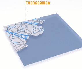 Places with similar names to Tường Ðại Hòa, Vietnam ::
Disclaimer :: Information on this page comes without warranty of any kind |
||
|
Where is Tường Ðại Hòa? Elevation and coordinates ::
Latitude (lat): 9°24'0"N Longitude (lon): 106°10'0"E
Elevation (approx.): 2m (map arrows pan, magnifying glasses zoom) |
||
|
Visiting Tường Ðại Hòa? Hotel/Accommodation ::
Book a hotel in Tường Ðại Hòa Travel Guide ::
Buy a travel guide for Vietnam rental cars ::
car rental offers GPS waypoint ::
download a GPX waypoint (PoI) of Tường Ðại Hòa for your GPS receiver
|
||