|
search place name
|
||
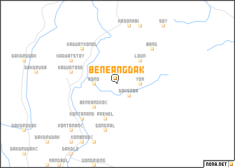
Bénêang Dak (Quảng Nam-Ðà Nẵng, Vietnam)Bénêang Dak is a town in the Quảng Nam-Ðà Nẵng region of Vietnam. An overview map of the region around Bénêang Dak is displayed below.
regional and 3d topo map of Bénêang Dak, Vietnam ::
Bénêang Dak airports ::
The nearest airport is DAD - Danang Intl, located 91.4 km north east of Bénêang Dak.
Nearby towns ::
Dak Saba (2.6km south east) //
Pơlei Gam (2.6km north west) //
Yom (3.6km east) //
Roro (3.6km west) //
Bénêang Ko (2) (5.2km south west) //
Loun (5.1km north east) //
Préhel (5.8km south) //
Gong Nal (7.6km south) //
Kaduat Ose (7.4km west) //
Kaduat Mang (7.4km west) //
Bang (7.7km north east) //
Kăduat Kơnol (7.7km north west) //
Kon Tanan (1) (7.7km south west) //
Kaduat Stoy (8.1km north west) //
Kon Tanan (2) (10.3km south west) //
[all distances 'as the bird flies' and approximate]  Places with similar names to Bénêang Dak, Vietnam ::
// Ban Ang Taek (TH)
// Ban Nong Dok (TH)
// Ban Nong Ta Kai (TH)
// Ban Nong Ta Kai (TH)
// Ban Nong Ta Kai (TH)
// Ban Nong Ta Kai (TH)
// Ban Nong Ta Kai (TH)
// Ban Nong Ta Kai (TH)
// Ban Nong Ta Kai (TH)
// Ban Nong Takai (TH)
Disclaimer :: Information on this page comes without warranty of any kind |
||
|
Where is Bénêang Dak? Elevation and coordinates ::
Latitude (lat): 15°17'0"N Longitude (lon): 107°52'0"E
Elevation (approx.): 784m (map arrows pan, magnifying glasses zoom) |
||
|
Visiting Bénêang Dak? Hotel/Accommodation ::
Book a hotel in Bénêang Dak Travel Guide ::
Buy a travel guide for Vietnam rental cars ::
car rental offers GPS waypoint ::
download a GPX waypoint (PoI) of Bénêang Dak for your GPS receiver
|
||