|
search place name
|
||
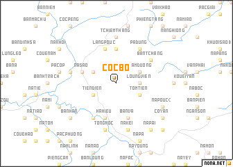
Coc Bo (Bắc Thái, Vietnam)Coc Bo is a town in the Bắc Thái region of Vietnam. An overview map of the region around Coc Bo is displayed below.
regional and 3d topo map of Coc Bo, Vietnam ::
Coc Bo airports ::
The nearest airport is HAN - Hanoi Noibai Intl, located 139.9 km south of Coc Bo.
Nearby towns ::
Loung Vien (3.4km east) //
Tom Tien (3.9km south east) //
Tham Duong (3.9km north east) //
Coc Moi (3.9km north east) //
Tien Dien (3.9km south west) //
Cao Ca (3.9km north west) //
Khau Vài (5.6km north) //
Bản Va (5.8km south) //
Na Sao (5.5km west) //
Làng Pouc (5.8km north) //
Hạ Hiệu (5.8km south) //
Pá Dưng (6.5km north east) //
Coue Zueuil (6.5km south west) //
Bản Tchang (6.3km north east) //
Tchiem Thang (7.4km north) //
Na Kei (7.6km south) //
Tong Moc (7.6km south) //
Coc Nua (7.1km west) //
Na Mouc (7.1km west) //
Na Pouc (2) (7.8km south east) //
Bản Foc (9.0km south east) //
Bản Pan (9.0km south east) //
Na Pai (9.0km south east) //
Co Yan (8.8km south east) //
Bản Han (8.8km south west) //
Bản Mec (10.1km south east) //
[all distances 'as the bird flies' and approximate]  Places with similar names to Coc Bo, Vietnam ::
Disclaimer :: Information on this page comes without warranty of any kind |
||
|
Where is Coc Bo? Elevation and coordinates ::
Latitude (lat): 22°29'0"N Longitude (lon): 105°52'0"E
Elevation (approx.): 489m (map arrows pan, magnifying glasses zoom) |
||
|
Visiting Coc Bo? Hotel/Accommodation ::
Book a hotel in Coc Bo Travel Guide ::
Buy a travel guide for Vietnam rental cars ::
car rental offers GPS waypoint ::
download a GPX waypoint (PoI) of Coc Bo for your GPS receiver
|
||