|
search place name
|
||
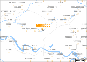
Ðông Cốc (Vietnam)Ðông Cốc is a town in Vietnam. An overview map of the region around Ðông Cốc is displayed below.
regional and 3d topo map of Ðông Cốc, Vietnam ::
Ðông Cốc airports ::
The nearest airport is SNO - Sakon Nakhon, located 230.1 km south west of Ðông Cốc.
Nearby towns ::
Bến Ðầu Voi (1.9km north) //
Phúc Cốc (1.8km west) //
Ðồng Vinh (2.6km north east) //
Ben Vao (3.5km west) //
Làng Rao (5.1km north east) //
Ben Tuong (7.0km west) //
Kẻ Chăm Dưới (7.6km north) //
Tri Lễ (8.2km south west) //
Chính Vĩnh (8.2km south west) //
Thong Tho (8.2km south west) //
Ðai Ðiền (9.1km south west) //
Xóm Ðông (10.2km south west) //
[all distances 'as the bird flies' and approximate]  Places with similar names to Ðông Cốc, Vietnam ::
// Tangkak (MY)
// Tăng Koŭk (KH)
// Tanéka-Koko (BJ)
// Tongkok (ID)
// Tincocc (PE)
// Tunga Kuku (NG)
// Tincocc (PE)
// Ting-kuei-k'o (TW)
// Ting-kuo-kou (TW)
// Ðông Cao (2) (VN)
Disclaimer :: Information on this page comes without warranty of any kind |
||
|
Where is Ðông Cốc? Elevation and coordinates ::
Latitude (lat): 19°1'0"N Longitude (lon): 105°10'0"E
Elevation (approx.): 37m (map arrows pan, magnifying glasses zoom) |
||
|
Visiting Ðông Cốc? Hotel/Accommodation ::
Book a hotel in Ðông Cốc Travel Guide ::
Buy a travel guide for Vietnam rental cars ::
car rental offers GPS waypoint ::
download a GPX waypoint (PoI) of Ðông Cốc for your GPS receiver
|
||