|
search place name
|
||
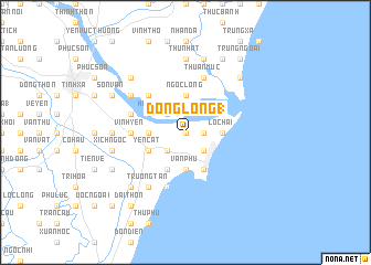
Dồng Lộng (1) (Thanh Hóa, Vietnam)Dồng Lộng (1) is a town in the Thanh Hóa region of Vietnam. An overview map of the region around Dồng Lộng (1) is displayed below.
regional and 3d topo map of Dồng Lộng (1), Vietnam ::
Dồng Lộng (1) airports ::
The nearest airport is HAN - Hanoi Noibai Intl, located 161.2 km north of Dồng Lộng (1).
Nearby towns ::
Hải Châu (0.0km north) //
Hóa Lộc (1.9km north) //
Hăi Thôn (1.7km east) //
Hoang Chung (2.5km north west) //
Hoa Chung (2.5km south west) //
Binh Tân (2.5km south east) //
Lương Trung (2.5km south east) //
Ngọc Long (3.7km north) //
Văn Lâm Thượng (3.5km west) //
Lôc Hải (3.5km east) //
Văn Phú (3.7km south) //
Trường Lệ (3.7km south) //
Tri Lê (3.7km south) //
Hà Dô (3.9km north west) //
Yên Cát (4.0km south west) //
Nho Quạn (4.1km south west) //
Sầm Sơn (4.1km south east) //
Dương Thành (5.1km north west) //
Thung Thôn (1) (5.2km west) //
Vĩnh Yên (5.2km west) //
Duy Tiếu (5.6km west) //
Mỹ Lâm (5.8km south) //
Ðống Hâ Dông (5.8km north) //
Na Thôn (5.8km north) //
Thuan Muc (5.8km north) //
Ðại Tiền (6.4km north west) //
Trương Tần (6.6km south west) //
Thứ Nhất (7.4km north) //
Ðằng Trung (7.4km north) //
[all distances 'as the bird flies' and approximate] 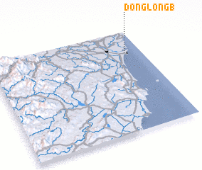 Places with similar names to Dồng Lộng (1), Vietnam ::
// Dungulangba (CD)
// Dongliangbi (CN)
Disclaimer :: Information on this page comes without warranty of any kind |
||
|
Where is Dồng Lộng (1)? Elevation and coordinates ::
Latitude (lat): 19°46'0"N Longitude (lon): 105°53'0"E
Elevation (approx.): 5m (map arrows pan, magnifying glasses zoom) |
||
|
Visiting Dồng Lộng (1)? Hotel/Accommodation ::
Book a hotel in Dồng Lộng (1) Travel Guide ::
Buy a travel guide for Vietnam rental cars ::
car rental offers GPS waypoint ::
download a GPX waypoint (PoI) of Dồng Lộng (1) for your GPS receiver
|
||