|
search place name
|
||
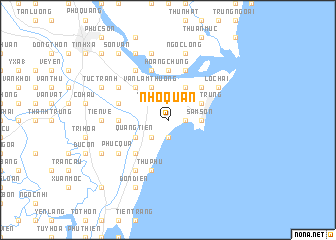
Nho Quạn (Thanh Hóa, Vietnam)Nho Quạn is a town in the Thanh Hóa region of Vietnam. An overview map of the region around Nho Quạn is displayed below.
regional and 3d topo map of Nho Quạn, Vietnam ::
Nho Quạn airports ::
The nearest airport is HAN - Hanoi Noibai Intl, located 164.8 km north of Nho Quạn.
Nearby towns ::
Mỹ Lâm (1.9km south) //
Tri Lê (1.7km east) //
Trường Lệ (1.7km east) //
Văn Phú (1.7km east) //
Hoa Chung (1.9km north) //
Trương Tần (2.5km south west) //
Yên Cát (2.5km north west) //
Sầm Sơn (3.5km east) //
Lương Trung (4.0km north east) //
Binh Tân (4.0km north east) //
Quảng Tiền (4.0km south west) //
Hải Châu (4.1km north east) //
Dồng Lộng (1) (4.1km north east) //
Văn Lâm Thượng (4.1km north west) //
Ðái Thôn (5.1km south west) //
Hăi Thôn (5.1km north east) //
Thung Thôn (1) (5.1km north west) //
Vĩnh Yên (5.1km north west) //
Hoang Chung (5.6km north) //
Thượng Ðình (5.2km west) //
Hóa Lộc (5.8km north) //
Xich Ngọc (5.6km west) //
Hà Dô (5.8km north) //
Thủ Phú (5.8km south) //
Phúc Quả (6.4km south west) //
Duy Tiếu (6.6km north west) //
Lưu Hiền (6.6km south west) //
Việt Yen (2) (6.4km north west) //
Lôc Hải (6.4km north east) //
[all distances 'as the bird flies' and approximate]  Places with similar names to Nho Quạn, Vietnam ::
Disclaimer :: Information on this page comes without warranty of any kind |
||
|
Where is Nho Quạn? Elevation and coordinates ::
Latitude (lat): 19°44'0"N Longitude (lon): 105°52'0"E
Elevation (approx.): 2m (map arrows pan, magnifying glasses zoom) |
||
|
Visiting Nho Quạn? Hotel/Accommodation ::
Book a hotel in Nho Quạn Travel Guide ::
Buy a travel guide for Vietnam rental cars ::
car rental offers GPS waypoint ::
download a GPX waypoint (PoI) of Nho Quạn for your GPS receiver
|
||