|
search place name
|
||
Ðông Mục (Vietnam)Ðông Mục is a town in Vietnam. An overview map of the region around Ðông Mục is displayed below.
regional and 3d topo map of Ðông Mục, Vietnam ::

Ðông Mục airports ::
The nearest airport is HAN - Hanoi Noibai Intl, located 73.6 km south east of Ðông Mục.
Nearby towns ::
Xóm Ngoi Lau (0.0km north) //
Thắng Ngãy (0.0km north) //
Ðong He (1.9km north) //
Khôn Tham (1.7km west) //
Dà Năng (1.7km east) //
Thượng Ấm (2.5km north west) //
Thượng Ấm (4.1km north west) //
Ðồng Van (4.1km north west) //
Làng Ca (1) (3.9km north east) //
Y Nhân (4.1km south west) //
Quang Linh (5.6km north) //
Tú Trạc (5.2km east) //
Tham Gia (5.8km north) //
Ðồng Lục (1) (5.8km south) //
Khúc Nô (6.5km south west) //
Làng Youc Xao (6.4km north west) //
Ðông Ðương (6.4km south west) //
Làng Ngơi Me (6.4km south west) //
Lai Xa (6.9km west) //
Làng Lạc (7.6km north) //
Ðong Hoan (7.1km east) //
Ðuông Mông (7.6km south) //
Khau Ma (7.6km south) //
Bắc Lũng (7.1km east) //
Sơn Dương (7.1km east) //
Da Ngua (7.6km south east) //
Ðong Tchong (7.8km north west) //
Khang Lực (7.8km north east) //
Ðồng Bằng (8.2km south west) //
[all distances 'as the bird flies' and approximate] 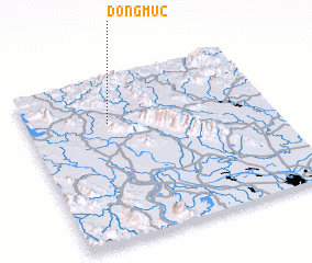 Places with similar names to Ðông Mục, Vietnam ::
// Tangmai Ga (MM)
// Taunggamauk (MM)
// Taungmauk (MM)
// Taungmauk (MM)
// Taungmauk (MM)
// Dîncu Mic (RO)
// Dîngău Mic (RO)
// Dongo-Moke (CD)
// Tangambuka (CD)
// Dongo-Moké (CG)
Disclaimer :: Information on this page comes without warranty of any kind |
||
|
Where is Ðông Mục? Elevation and coordinates ::
Latitude (lat): 21°43'0"N Longitude (lon): 105°20'0"E
Elevation (approx.): 69m (map arrows pan, magnifying glasses zoom) |
||
|
Visiting Ðông Mục? Hotel/Accommodation ::
Book a hotel in Ðông Mục Travel Guide ::
Buy a travel guide for Vietnam rental cars ::
car rental offers GPS waypoint ::
download a GPX waypoint (PoI) of Ðông Mục for your GPS receiver
|
||