|
search place name
|
||
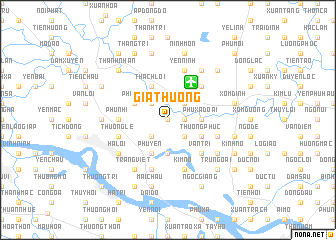
Gia Thượng (Vietnam)Gia Thượng is a town in Vietnam. An overview map of the region around Gia Thượng is displayed below.
regional and 3d topo map of Gia Thượng, Vietnam ::
Gia Thượng airports ::
The nearest airport is HAN - Hanoi Noibai Intl, located 4.9 km north east of Gia Thượng.
Nearby towns ::
Gia Trung (0.0km north) //
Thụy Ha (1.7km east) //
Gio Nhan (2.5km south west) //
Giai Lạc (2.5km north west) //
Tang My (2.5km south east) //
Hương Gia (2.5km north east) //
Cổ Nhue (3.7km south) //
Phù Xá Ðoài (3.5km east) //
Phu Yen (4.1km south west) //
Phù Trì (3.9km north west) //
Thạch Lỗi (4.1km north west) //
Thượng Phuc (3.9km south east) //
Vân Trì (5.1km south east) //
Nội Bài (5.1km north east) //
Phu Nhi (5.2km west) //
Thương Lệ (5.5km west) //
Hậu Dương (5.8km south) //
Cổ Dương (5.5km east) //
Quan Am (5.5km east) //
Kim Nỗ (5.8km south) //
Ninh Bắc (5.8km north) //
Yên Ninh (5.8km north) //
Tráng Việt (6.5km south west) //
Hạ Lồi (6.4km south west) //
Ðông Cao (6.4km south west) //
Châm Mo (6.4km south east) //
Xuân Bách (6.5km north east) //
Nội Ðộng (6.9km west) //
Mai Chầu (7.6km south) //
[all distances 'as the bird flies' and approximate] 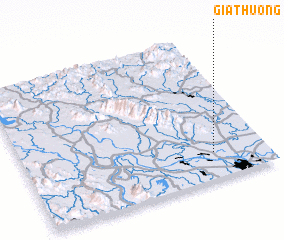 Places with similar names to Gia Thượng, Vietnam ::
Disclaimer :: Information on this page comes without warranty of any kind |
||
|
Where is Gia Thượng? Elevation and coordinates ::
Latitude (lat): 21°11'0"N Longitude (lon): 105°47'0"E
Elevation (approx.): 16m (map arrows pan, magnifying glasses zoom) |
||
|
Visiting Gia Thượng? Hotel/Accommodation ::
Book a hotel in Gia Thượng Travel Guide ::
Buy a travel guide for Vietnam rental cars ::
car rental offers GPS waypoint ::
download a GPX waypoint (PoI) of Gia Thượng for your GPS receiver
|
||