|
search place name
|
||
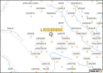
Làng Ba Ban (Thanh Hóa, Vietnam)Làng Ba Ban is a town in the Thanh Hóa region of Vietnam. An overview map of the region around Làng Ba Ban is displayed below.
regional and 3d topo map of Làng Ba Ban, Vietnam ::
Làng Ba Ban airports ::
The nearest airport is HAN - Hanoi Noibai Intl, located 100.4 km north east of Làng Ba Ban.
Nearby towns ::
Nam Mươi (1.9km south) //
Tuông To (2.5km north west) //
Nước Ka (3.5km east) //
Làng Nua (3.9km south west) //
Qui Mỹ (5.1km north east) //
Làng Son (5.1km south east) //
Làng Bô Xa (5.1km south west) //
Mong Luông (5.2km east) //
Xóm Giều (5.5km east) //
Làng Cào (5.8km south) //
Làng Chiêu (6.6km south east) //
Làng Chiên (1) (6.6km south west) //
Phù Biêng (7.4km north) //
Làng Hô (6.9km west) //
Ðông Triềng (8.2km north east) //
Làng Vô (7.9km south east) //
Lũng Tiềm (9.1km south west) //
Làng Bang (8.9km south west) //
Ðac Hày (1) (10.2km north west) //
Bô Phoi (10.2km north east) //
[all distances 'as the bird flies' and approximate]  Places with similar names to Làng Ba Ban, Vietnam ::
// Langbaban (PH)
Disclaimer :: Information on this page comes without warranty of any kind |
||
|
Where is Làng Ba Ban? Elevation and coordinates ::
Latitude (lat): 20°31'0"N Longitude (lon): 105°12'0"E
Elevation (approx.): 881m (map arrows pan, magnifying glasses zoom) |
||
|
Visiting Làng Ba Ban? Hotel/Accommodation ::
Book a hotel in Làng Ba Ban Travel Guide ::
Buy a travel guide for Vietnam rental cars ::
car rental offers GPS waypoint ::
download a GPX waypoint (PoI) of Làng Ba Ban for your GPS receiver
|
||