|
search place name
|
||
Nhà Thờ (Sóc Trăng, Vietnam)Nhà Thờ is a town in the Sóc Trăng region of Vietnam. An overview map of the region around Nhà Thờ is displayed below.
regional and 3d topo map of Nhà Thờ, Vietnam ::

Nhà Thờ airports ::
The nearest airport is SGN - Ho Chi Minh City Tansonnhat Intl, located 147.1 km north of Nhà Thờ.
Other airports nearby include PNH - Phnom-penh Phnom Penh Intl (265.6 km north west), Nearby towns ::
Ngoài Vàm (2.9km south west) //
Bưng Cốc (4.0km west) //
Xóm Bà Keo (4.1km north east) //
Xóm Rạch Trang (4.3km east) //
Ấp Ngan Rô (4.6km south west) //
An Thanh Nhì (4.7km east) //
Xóm Luối (5.6km south west) //
Trùng Bình (6.3km south west) //
Xóm Xo Ro (6.5km north west) //
Xóm Tú Diễm (6.6km west) //
Xóm Rạch Lớn (6.9km north) //
Ấp Nước Mặn (1) (8.1km west) //
Ấp Nhà Việc (8.4km south west) //
Ðại Ân (8.5km north west) //
Ấp Nước Mặn Ngoài (8.7km north west) //
Tà Mun (8.8km west) //
Giồng Nhum (9.0km north east) //
Ấp Cá Lóc (9.5km north east) //
Giồng Ðinh (10.0km north east) //
Long Phú (10.1km north west) //
Ấp Vĩnh Hưng (10.5km north west) //
Ấp Ðầu Giồng (11.1km south west) //
[all distances 'as the bird flies' and approximate] 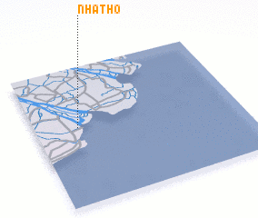 Places with similar names to Nhà Thờ, Vietnam ::
// Nhữ Th (VN)
Disclaimer :: Information on this page comes without warranty of any kind |
||
|
Where is Nhà Thờ? Elevation and coordinates ::
Latitude (lat): 9°33'44"N Longitude (lon): 106°12'41"E
Elevation (approx.): 5m (map arrows pan, magnifying glasses zoom) |
||
|
Visiting Nhà Thờ? Hotel/Accommodation ::
Book a hotel in Nhà Thờ Travel Guide ::
Buy a travel guide for Vietnam rental cars ::
car rental offers GPS waypoint ::
download a GPX waypoint (PoI) of Nhà Thờ for your GPS receiver
|
||