|
search place name
|
||
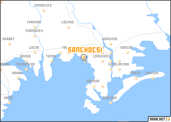
San Choc Si (Quảng Ninh, Vietnam)San Choc Si is a town in the Quảng Ninh region of Vietnam. An overview map of the region around San Choc Si is displayed below.
regional and 3d topo map of San Choc Si, Vietnam ::
San Choc Si airports ::
The nearest airport is NNG - Nanning Wuxu, located 123.7 km north of San Choc Si.
Nearby towns ::
Ðoan Tĩnh (0.0km north) //
Slein Hao Lan (2.5km north east) //
Long Kiềng (3.4km east) //
Qua Phố (3.9km north east) //
Hong Ham (3.9km north west) //
Tai Pho (3.9km north west) //
Na Xin (3.9km north west) //
Na Vang (3.9km north west) //
Chuc Tchia (5.2km east) //
Nam Quat (5.5km west) //
Vàn Ninh (5.8km south) //
Móng Cái (5.5km east) //
Sec Kep (5.5km east) //
Nam Thon (6.5km south east) //
Dongxing (6.4km north east) //
Ðong Thon (6.9km east) //
Cốt Ðoài (6.9km west) //
Ten Mo (6.9km west) //
Ho Viêt (7.1km east) //
Xuân Lạn Nam (7.1km east) //
Lộc Phù (8.2km north west) //
[all distances 'as the bird flies' and approximate] 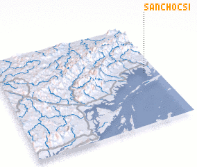 Places with similar names to San Choc Si, Vietnam ::
// Sanchequias (PT)
// Xinchexu (CN)
Disclaimer :: Information on this page comes without warranty of any kind |
||
|
Where is San Choc Si? Elevation and coordinates ::
Latitude (lat): 21°31'0"N Longitude (lon): 107°55'0"E
Elevation (approx.): 3m (map arrows pan, magnifying glasses zoom) |
||
|
Visiting San Choc Si? Hotel/Accommodation ::
Book a hotel in San Choc Si Travel Guide ::
Buy a travel guide for Vietnam rental cars ::
car rental offers GPS waypoint ::
download a GPX waypoint (PoI) of San Choc Si for your GPS receiver
|
||