|
search place name
|
||
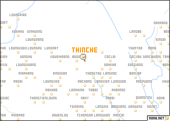
Thin Ché (Cao Bằng, Vietnam)Thin Ché is a town in the Cao Bằng region of Vietnam. An overview map of the region around Thin Ché is displayed below.
regional and 3d topo map of Thin Ché, Vietnam ::
Thin Ché airports ::
The nearest airport is HAN - Hanoi Noibai Intl, located 188.1 km south of Thin Ché.
Nearby towns ::
Nam Dong (0.0km north) //
Bo Gai (1.7km west) //
Nám Giựa (2.5km south west) //
Phia Hoảng (3.9km north east) //
Phia Deng (3.9km south east) //
Thong Tau (4.1km south east) //
Ðỏng Go (4.1km south east) //
Lộng Ái (4.1km south east) //
Làng Ngằm (5.0km south east) //
Kouei Hoang (5.1km west) //
Pả Chang (5.6km south) //
Cốc Lại (5.1km east) //
Mu Cải (5.8km south) //
Sam Kha (5.4km east) //
Làng Kiển (6.5km south east) //
Ping Sion (6.3km south west) //
Làng Roc (6.3km south east) //
Lung Mat (7.1km west) //
Ta Bốc (7.6km south) //
Lòn Phinh (7.6km south) //
Kiao Xa Ping (7.6km south west) //
Ché Cà (8.2km south east) //
Làng Cốc Phát (8.2km south west) //
Làng Thốc (8.8km south east) //
Lủng Goái (8.8km south east) //
Loung Xeo (8.8km south west) //
Nà Bó (9.0km south east) //
Phan Noc (10.1km south east) //
Pa Khao (10.1km south west) //
[all distances 'as the bird flies' and approximate]  Places with similar names to Thin Ché, Vietnam ::
// Thanásia (GR)
// Thanh Chau (VN)
// Thanh Chiểu (VN)
// Thịnh Châu (VN)
// Thôn Chày (VN)
// Thuận Châu (VN)
Disclaimer :: Information on this page comes without warranty of any kind |
||
|
Where is Thin Ché? Elevation and coordinates ::
Latitude (lat): 22°55'0"N Longitude (lon): 105°55'0"E
Elevation (approx.): 634m (map arrows pan, magnifying glasses zoom) |
||
|
Visiting Thin Ché? Hotel/Accommodation ::
Book a hotel in Thin Ché Travel Guide ::
Buy a travel guide for Vietnam rental cars ::
car rental offers GPS waypoint ::
download a GPX waypoint (PoI) of Thin Ché for your GPS receiver
|
||