|
search place name
|
||
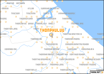
Thôn Phù Lưu (Vietnam)Thôn Phù Lưu is a town in Vietnam. An overview map of the region around Thôn Phù Lưu is displayed below.
regional and 3d topo map of Thôn Phù Lưu, Vietnam ::
Thôn Phù Lưu airports ::
The nearest airport is DAD - Danang Intl, located 137.0 km south east of Thôn Phù Lưu.
Other airports nearby include PKZ - Pakse (237.9 km south west), Nearby towns ::
Thôn Bố Liễu (0.0km north) //
Thôn Trà Liên Tây (1.8km west) //
Thôn Ðại Hào (1.9km north) //
Thôn Ðại Lộc (1.9km north) //
Thôn Hà My (1.9km south) //
Tân Ðịnh (1.9km south) //
Thôn Văn Hoa (1) (1.8km east) //
Bích La (1.9km south) //
Tả Kiên (2.6km south west) //
Nho Ly (3.7km north) //
Triệu Phong (3.7km south) //
Minh Hương (3.7km south) //
Thôn Phú Liễu (3.5km east) //
Phước Lệ (4.1km north west) //
Thôn Trung Chỉ (1) (4.0km north west) //
Thôn Dương Lệ Văn (4.0km north west) //
Thôn Dường Lộc (4.0km north west) //
Phước Mỹ (4.0km south west) //
Bích Khê (4.1km south east) //
Quy Thiện (4.1km south east) //
Thôn Linh An (1) (4.0km north east) //
Thanh Liêm (5.1km north west) //
Thôn Ái Tử (1) (5.1km south west) //
Thôn Long Quang (1) (5.1km north east) //
Cao Hy (5.6km north) //
Lương Kim (5.6km north) //
Thôn Nhan Biều (1) (5.6km south) //
Thôn Lâp Thach (1) (5.6km west) //
Thôn Ðông Hà (5.6km west) //
[all distances 'as the bird flies' and approximate]  Places with similar names to Thôn Phù Lưu, Vietnam ::
// Thanvillé (FR)
// Thionville (FR)
// Thonville (FR)
// Thôn Phú Liễu (VN)
// Thionville (FR)
// Thanville (BE)
Disclaimer :: Information on this page comes without warranty of any kind |
||
|
Where is Thôn Phù Lưu? Elevation and coordinates ::
Latitude (lat): 16°48'0"N Longitude (lon): 107°11'0"E
Elevation (approx.): 7m (map arrows pan, magnifying glasses zoom) |
||
|
Visiting Thôn Phù Lưu? Hotel/Accommodation ::
Book a hotel in Thôn Phù Lưu Travel Guide ::
Buy a travel guide for Vietnam rental cars ::
car rental offers GPS waypoint ::
download a GPX waypoint (PoI) of Thôn Phù Lưu for your GPS receiver
|
||