|
search place name
|
||
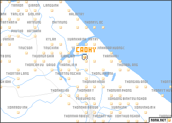
Cao Hy (Vietnam)Cao Hy is a town in Vietnam. An overview map of the region around Cao Hy is displayed below.
regional and 3d topo map of Cao Hy, Vietnam ::
Cao Hy airports ::
The nearest airport is DAD - Danang Intl, located 140.5 km south east of Cao Hy.
Other airports nearby include PKZ - Pakse (242.2 km south west), Nearby towns ::
Lương Kim (0.0km north) //
Lễ Xuyên (1.8km east) //
Nho Ly (1.9km south) //
Dương Xuân (2.6km north west) //
Yên Cư (2.6km north west) //
Phước Lệ (2.6km south west) //
Giáo Liêm (3.5km west) //
Xóm Cồn Tòng (3.7km north) //
Tường Vân (3.7km north) //
Thôn Ðại Lộc (3.7km south) //
Thôn Ðại Hào (3.7km south) //
Xuân Khánh (4.1km north west) //
Mai Xá Chanh (4.0km north west) //
Thanh Liêm (4.0km south west) //
Hà Tây (4.1km north east) //
Phó Hội (4.1km north east) //
Thôn Long Quang (1) (4.0km south east) //
Thôn Trung Chỉ (1) (5.1km south west) //
Thôn Dường Lộc (5.1km south west) //
Thôn Dương Lệ Văn (5.1km south west) //
Thôn Linh An (1) (5.1km south east) //
Gia Ðô (5.3km west) //
Thanh Hôi (5.3km east) //
Thôn Phù Lưu (5.6km south) //
Thôn Bố Liễu (5.6km south) //
Thôn Trà Liên Tây (5.8km south) //
Vinh Quan Hạ (5.6km west) //
Vĩnh Hòa Phường (2) (5.6km east) //
An Gia (5.6km west) //
[all distances 'as the bird flies' and approximate]  Places with similar names to Cao Hy, Vietnam ::
Disclaimer :: Information on this page comes without warranty of any kind |
||
|
Where is Cao Hy? Elevation and coordinates ::
Latitude (lat): 16°51'0"N Longitude (lon): 107°11'0"E
Elevation (approx.): 4m (map arrows pan, magnifying glasses zoom) |
||
|
Visiting Cao Hy? Hotel/Accommodation ::
Book a hotel in Cao Hy Travel Guide ::
Buy a travel guide for Vietnam rental cars ::
car rental offers GPS waypoint ::
download a GPX waypoint (PoI) of Cao Hy for your GPS receiver
|
||