|
search place name
|
||
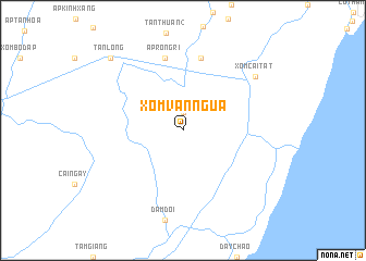
Xóm Ván Ngừa (Minh Hải, Vietnam)Xóm Ván Ngừa is a town in the Minh Hải region of Vietnam. An overview map of the region around Xóm Ván Ngừa is displayed below.
regional and 3d topo map of Xóm Ván Ngừa, Vietnam ::
Xóm Ván Ngừa airports ::
The nearest airport is SGN - Ho Chi Minh City Tansonnhat Intl, located 259.5 km north east of Xóm Ván Ngừa.
Nearby towns ::
Ấp Ông Năm (1.9km north) //
Ấp Bá Năm (7.6km north) //
Ấp Rồng Ri (7.6km north) //
Xóm Cái Tất (9.2km north east) //
Thuận Hòa (9.2km north east) //
Tân Long (10.4km north west) //
[all distances 'as the bird flies' and approximate] 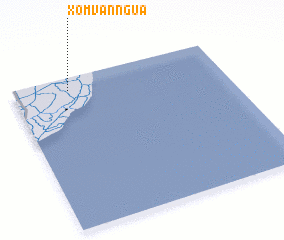 Places with similar names to Xóm Ván Ngừa, Vietnam ::
// Zimovniki (RU)
// Simfunka (ZM)
// Sao Mo Phing (VN)
// Xóm Bào Phong (VN)
// Xóm Phương (VN)
// Xóm Phương (VN)
// Xóm Vung (VN)
// Xóm Vương (VN)
// Xóm Vàng (VN)
// Xiaomafang (CN)
Disclaimer :: Information on this page comes without warranty of any kind |
||
|
Where is Xóm Ván Ngừa? Elevation and coordinates ::
Latitude (lat): 8°55'0"N Longitude (lon): 105°16'0"E
Elevation (approx.): 5m (map arrows pan, magnifying glasses zoom) |
||
|
Visiting Xóm Ván Ngừa? Hotel/Accommodation ::
Book a hotel in Xóm Ván Ngừa Travel Guide ::
Buy a travel guide for Vietnam rental cars ::
car rental offers GPS waypoint ::
download a GPX waypoint (PoI) of Xóm Ván Ngừa for your GPS receiver
|
||