|
search place name
|
||
Yang Ma Sin Tiay (Lai Châu, Vietnam)Yang Ma Sin Tiay is a town in the Lai Châu region of Vietnam. An overview map of the region around Yang Ma Sin Tiay is displayed below.
regional and 3d topo map of Yang Ma Sin Tiay, Vietnam ::

Nearby towns ::
Sin Cao (1) (1.9km south) //
Yang Ma Sin Cao (1.9km south) //
Su Tâng Hô (1.9km south) //
Pin Hô (2.5km south west) //
Sin Cao (2) (2.5km south east) //
Ma Pô Chai (2.5km north west) //
Lo Suối Tong (3.9km south west) //
San Tia (3.9km north west) //
Ta Leng (3.9km north west) //
Pin Tiay (4.1km south east) //
Sin Cao (3) (4.1km south west) //
Heo Sou San (5.0km south west) //
Seo Lung Than (5.0km north west) //
Talung Than (5.0km north west) //
Ho Tao (5.0km south east) //
Tam Duong (5.1km west) //
Kin Tiou (5.1km west) //
Can Hô (5.1km west) //
Na Bo (6.5km south west) //
Coc Pia (6.5km south west) //
Pan Linh (6.3km south west) //
Pin Ngan Tiay (6.3km north west) //
Bản Hon (7.4km south) //
Seo Lan Than (7.1km west) //
Pan Linh (7.1km west) //
Lan Than (7.1km west) //
Seo Lung Than (7.1km west) //
Can Hô (7.1km west) //
Hon Ngay (7.6km south west) //
[all distances 'as the bird flies' and approximate] 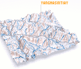 Places with similar names to Yang Ma Sin Tiay, Vietnam :: Disclaimer :: Information on this page comes without warranty of any kind |
||
|
Where is Yang Ma Sin Tiay? Elevation and coordinates ::
Latitude (lat): 22°24'0"N Longitude (lon): 103°33'0"E
Elevation (approx.): 1444m (map arrows pan, magnifying glasses zoom) |
||
|
Visiting Yang Ma Sin Tiay? Hotel/Accommodation ::
Book a hotel in Yang Ma Sin Tiay Travel Guide ::
Buy a travel guide for Vietnam rental cars ::
car rental offers GPS waypoint ::
download a GPX waypoint (PoI) of Yang Ma Sin Tiay for your GPS receiver
|
||