|
search place name
|
||
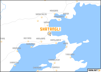
Shatangli (Fujian, China)Shatangli is a town in the Fujian region of China. An overview map of the region around Shatangli is displayed below.
regional and 3d topo map of Shatangli, China ::
Shatangli airports ::
The nearest airport is MZW - Matsu Beigan, located 66.0 km south of Shatangli.
Other airports nearby include FOC - Fuzhou Changle (104.6 km south), TPE - Taipei Chiang Kai Shek Intl (227.4 km south east), TSA - Taipei Sungshan (246.5 km south east), Nearby towns ::
Hongjiang (3.2km south east) //
Hanjiang (3.7km south west) //
Dasha (4.1km north) //
Songshan (6.7km north east) //
Wuqu (6.5km south east) //
Zhouyang (7.0km north west) //
Songcheng (7.6km north west) //
Shajiang (7.5km south west) //
Hougang (8.5km north) //
Meiyang (7.7km west) //
Qingqi (8.8km north east) //
Tingxiaxi (10.3km south east) //
[all distances 'as the bird flies' and approximate]  Places with similar names to Shatangli, China ::
// Chitungulu (ZM)
// Shādīni Kili (PK)
// Chidenguele (MZ)
// Chitunguli (MZ)
// Ch'oedong-gol (KP)
// Ch'ieh-tung-li (TW)
// Ch'i-ting-li (TW)
// Shitangluo (CN)
// Shitangluo (CN)
// Chiddingly (GB)
Disclaimer :: Information on this page comes without warranty of any kind |
||
|
Where is Shatangli? Elevation and coordinates ::
Latitude (lat): 26°49'8"N Longitude (lon): 120°1'51"E
Elevation (approx.): 11m (map arrows pan, magnifying glasses zoom) |
||
|
Visiting Shatangli? Hotel/Accommodation ::
Book a hotel in Shatangli Travel Guide ::
Buy a travel guide for China rental cars ::
car rental offers GPS waypoint ::
download a GPX waypoint (PoI) of Shatangli for your GPS receiver
|
||