|
search place name
|
||
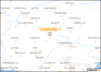
Chiddingly (United Kingdom)Chiddingly is a town in United Kingdom. An overview map of the region around Chiddingly is displayed below.
regional and 3d topo map of Chiddingly, United Kingdom ::
Chiddingly airports ::
The nearest airport is ESH - Shoreham By Sea Shoreham, located 34.6 km west of Chiddingly.
Other airports nearby include LGW - London Gatwick (38.1 km north west), BQH - Biggin Hill (49.1 km north), LYX - Lydd (53.5 km east), LCY - London City (67.9 km north), Nearby towns ::
East Hoathly (2.2km north west) //
Pyecombe (2.2km south west) //
Waldron (3.9km north) //
Laughton (4.0km south west) //
Horsebridge (5.1km south east) //
Chalvington (6.0km south west) //
Horam (5.0km east) //
Ripe (6.6km south west) //
Framfield (6.6km north west) //
Hellingly (6.0km south east) //
Cross in Hand (7.8km north) //
Selmeston (8.2km south west) //
[all distances 'as the bird flies' and approximate] 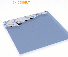 Places with similar names to Chiddingly, United Kingdom ::
// Chitungulu (ZM)
// Shādīni Kili (PK)
// Chidenguele (MZ)
// Chitunguli (MZ)
// Ch'oedong-gol (KP)
// Ch'ieh-tung-li (TW)
// Ch'i-ting-li (TW)
// Shatangli (CN)
// Shitangluo (CN)
// Shitangluo (CN)
Disclaimer :: Information on this page comes without warranty of any kind |
||
|
Where is Chiddingly? Elevation and coordinates ::
Latitude (lat): 50°54'0"N Longitude (lon): 0°11'0"W
Elevation (approx.): 33m (map arrows pan, magnifying glasses zoom) |
||
|
Visiting Chiddingly? Hotel/Accommodation ::
Book a hotel in Chiddingly Travel Guide ::
rental cars ::
car rental offers GPS waypoint ::
download a GPX waypoint (PoI) of Chiddingly for your GPS receiver
|
||