|
search place name
|
||
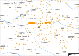
Aḑ Ḑabaratayn (Al Ḩudaydah, Yemen)Aḑ Ḑabaratayn is a town in the Al Ḩudaydah region of Yemen. An overview map of the region around Aḑ Ḑabaratayn is displayed below.
regional and 3d topo map of Aḑ Ḑabaratayn, Yemen ::
Nearby towns ::
Aḑ Ḑabaratayn al Maḩāşim (1.0km south) //
Al Haddārīyah (1.1km west) //
Buyūt al Başābiş (1.5km north) //
Dimnat al Haddārah (2.1km north west) //
Om Mari (2.2km north east) //
Al Manz̧ar (2.2km south east) //
Buyūt al Maḩādibah (2.3km north) //
Buyūt al Kudayshah (2.3km east) //
Buyūt ad Dalāshāʼ (2.4km south east) //
Ḩāsī Muḩammad (2.7km south west) //
As Sawlah (2.8km south) //
Bayt az Zawraqī (2.8km west) //
Aḑ Ḑabarah (3.0km south) //
Al Kalaḩah (3.3km north) //
Bayt al Farīd (3.4km south) //
Al Kudayrah (3.5km south west) //
Al Ghuzzīyah (3.7km north) //
Ḩumāsīyah (3.7km east) //
Ash Sharīfīyah (3.8km south east) //
Al Jurbishīyah (3.8km east) //
Al Kadīd (4.0km south) //
Buyūt al Ma‘arīf (4.2km east) //
Al Wisāyah (4.4km south east) //
Dayr al Muhdah (4.5km north west) //
Al Kathīr (4.5km north) //
Dayr Sīb ‘Alī (5.0km north east) //
Al Maşabah (5.0km south west) //
Al Qāʼim (5.2km south) //
Al Marāmīd (5.2km south east) //
[all distances 'as the bird flies' and approximate]  Places with similar names to Aḑ Ḑabaratayn, Yemen ::
// Aḑ Ḑubāratayn (YE)
Disclaimer :: Information on this page comes without warranty of any kind |
||
|
Where is Aḑ Ḑabaratayn? Elevation and coordinates ::
Latitude (lat): 14°35'8"N Longitude (lon): 43°23'12"E
Elevation (approx.): 135m (map arrows pan, magnifying glasses zoom) |
||
|
Visiting Aḑ Ḑabaratayn? Hotel/Accommodation ::
Book a hotel in Aḑ Ḑabaratayn Travel Guide ::
Buy a travel guide for Yemen rental cars ::
car rental offers GPS waypoint ::
download a GPX waypoint (PoI) of Aḑ Ḑabaratayn for your GPS receiver
|
||