|
search place name
|
||
Al Maqlūbah (Al Ḩudaydah, Yemen)Al Maqlūbah is a town in the Al Ḩudaydah region of Yemen. An overview map of the region around Al Maqlūbah is displayed below.
regional and 3d topo map of Al Maqlūbah, Yemen ::

Nearby towns ::
Mahalemi (1.2km north) //
Al Majāhişah (2.4km south east) //
Al Qawqar (2.4km north west) //
Al Maşabah (3.0km south east) //
Bayt as Sayyid Habbah (3.1km north) //
Meijamie (3.1km north) //
Al Mūsīyah (3.2km south west) //
Shābbīyah (3.4km west) //
Kidf al Majāhişah (3.7km south) //
Bayt az Zawraqī (3.6km east) //
Ḩāsī Muḩammad (3.7km east) //
Şabrah (4.2km south west) //
Buyūt an Nahārīyīn (4.2km west) //
Bayt al Faqīr (4.4km south) //
Aţ Ţabbālīyah (4.4km south) //
Al Kudayrah (5.0km east) //
Buyūt al Hawāshim (5.3km west) //
Qaryat aţ Ţabbālīyah (5.4km south east) //
Al Haddārīyah (5.4km east) //
At Turbah (5.6km south west) //
Bayt al Farīd (5.8km east) //
Ad Damāh (6.1km south east) //
Dimnat al Haddārah (6.0km north east) //
Dayr al Muhdah (6.1km north east) //
Bayt al Faqīh (6.3km south) //
Dayr al Wayţ (6.4km north) //
Somani (6.4km south) //
Aḑ Ḑabaratayn (6.3km east) //
As Sawlah (6.3km east) //
[all distances 'as the bird flies' and approximate] 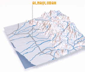 Places with similar names to Al Maqlūbah, Yemen ::
// Al Muqaylībah (SY)
Disclaimer :: Information on this page comes without warranty of any kind |
||
|
Where is Al Maqlūbah? Elevation and coordinates ::
Latitude (lat): 14°34'22"N Longitude (lon): 43°19'46"E
Elevation (approx.): 97m (map arrows pan, magnifying glasses zoom) |
||
|
Visiting Al Maqlūbah? Hotel/Accommodation ::
Book a hotel in Al Maqlūbah Travel Guide ::
Buy a travel guide for Yemen rental cars ::
car rental offers GPS waypoint ::
download a GPX waypoint (PoI) of Al Maqlūbah for your GPS receiver
|
||