|
search place name
|
||
Jeraba (Yemen)Jeraba is a town in Yemen. An overview map of the region around Jeraba is displayed below.
regional and 3d topo map of Jeraba, Yemen ::
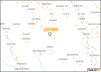
Nearby towns ::
Masn‘ah (1.6km south east) //
Chail (3.4km north) //
Al ‘Usayyif (4.5km north west) //
Ruhbah (4.9km north) //
Ma‘ārif (5.2km south) //
Ar Rakoab (6.2km south) //
Al Aslamah (6.7km south) //
Firi‘ (7.1km north) //
Al Hajra (7.1km north west) //
Al Qaryah (7.1km north west) //
Qiryat al ‘Ubayd (7.4km south west) //
Nashaq (7.5km north west) //
Sākin Badrah (7.7km south west) //
Qaryat Āl ‘Ubayd (7.7km south west) //
Marhūb (8.5km north west) //
Dijjar (8.5km west) //
Makhran (8.8km west) //
Alela (9.2km north east) //
Burāt (9.7km north west) //
Kusaba (11.1km north west) //
Ad Danabah (11.5km south east) //
[all distances 'as the bird flies' and approximate] 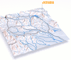 Places with similar names to Jeraba, Yemen ::
Disclaimer :: Information on this page comes without warranty of any kind |
||
|
Where is Jeraba? Elevation and coordinates ::
Latitude (lat): 13°31'12"N Longitude (lon): 44°43'43"E
Elevation (approx.): 837m (map arrows pan, magnifying glasses zoom) |
||
|
Visiting Jeraba? Hotel/Accommodation ::
Book a hotel in Jeraba Travel Guide ::
Buy a travel guide for Yemen rental cars ::
car rental offers GPS waypoint ::
download a GPX waypoint (PoI) of Jeraba for your GPS receiver
|
||