|
search place name
|
||
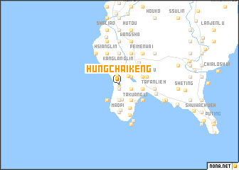
Hung-ch'ai-k'eng (T'ai-wan, Taiwan)Hung-ch'ai-k'eng is a town in the T'ai-wan region of Taiwan. An overview map of the region around Hung-ch'ai-k'eng is displayed below.
regional and 3d topo map of Hung-ch'ai-k'eng, Taiwan ::
Hung-ch'ai-k'eng airports ::
The nearest airport is KHH - Kaohsiung Intl, located 77.0 km north west of Hung-ch'ai-k'eng.
Other airports nearby include PIF - Pingtung South (81.9 km north), KYD - Lanyu (84.5 km east), TTT - Fengnin (95.3 km north east), GNI - Green Island Lyudao (109.5 km north east), Nearby towns ::
Hung-ch'ai (0.0km north) //
Pin-lang (0.6km south) //
Shan-hai-li (1.5km north) //
Ts'ao-t'an (1.8km east) //
Lung-ch'üan (1.9km north east) //
Ch'ih-k'an (2.1km north east) //
Ta-chia-tung (2.3km south) //
Shu-lin (2.4km south) //
Sha-wei-wu (3.0km south east) //
Shui-ch'üan-chuang (3.0km south west) //
Te-ho-li (3.1km north) //
K'ang-lang-lin (3.1km north) //
Wan-li-tung (3.6km north west) //
Ma-an-shan (3.4km east) //
Ta-kuang-li (3.6km south east) //
Pi-tzu-t'ou (3.6km east) //
Shan-chiao-li (3.6km east) //
Shang-shui-ch'üan (3.9km south east) //
Pai-sha (4.0km south) //
Mao-pi (4.3km south) //
Shih-tzu-t'ou (4.2km south east) //
Pi-tzu-t'ou (4.2km east) //
Heng-ch'un (4.5km north east) //
Chen-nan-kung (4.6km north east) //
Ssu-kou (5.0km north) //
San-kou (5.0km north) //
Hsia-shui-ch'üan (5.0km south) //
Ch'un-pu (5.2km north) //
Hsiang-lin (5.3km north) //
[all distances 'as the bird flies' and approximate]  Places with similar names to Hung-ch'ai-k'eng, Taiwan ::
// Hung-shui-k'eng (TW)
// Hung-shui-k'eng (TW)
// Huang-chu-k'eng (TW)
// Hongshagang (CN)
// Hongshuigang (CN)
// Huangshagang (CN)
// Huangshagang (CN)
// Huangshagang (CN)
// Huangshagang (CN)
// Huangshakeng (CN)
Disclaimer :: Information on this page comes without warranty of any kind |
||
|
Where is Hung-ch'ai-k'eng? Elevation and coordinates ::
Latitude (lat): 21°58'19"N Longitude (lon): 120°43'2"E
Elevation (approx.): 16m (map arrows pan, magnifying glasses zoom) |
||
|
Visiting Hung-ch'ai-k'eng? Hotel/Accommodation ::
Book a hotel in Hung-ch'ai-k'eng Travel Guide ::
Buy a travel guide for Taiwan rental cars ::
car rental offers GPS waypoint ::
download a GPX waypoint (PoI) of Hung-ch'ai-k'eng for your GPS receiver
|
||