|
search place name
|
||
Ivanje (Srbija, Serbia and Montenegro)Ivanje is a town in the Srbija region of Serbia and Montenegro. An overview map of the region around Ivanje is displayed below.
regional and 3d topo map of Ivanje, Serbia and Montenegro ::

Ivanje airports ::
The nearest airport is PRN - Pristina, located 97.0 km south east of Ivanje.
Other airports nearby include INI - Nis (111.8 km east), TGD - Podgorica (148.1 km south west), BEG - Beograd (164.5 km north), TIV - Tivat (177.0 km south west), Nearby towns ::
Ravni (0.9km south) //
Jablanovik (1.7km north east) //
Sase (1.6km south west) //
Boroviće (2.2km south) //
Ladovići (2.2km south) //
Kotiljevac (2.3km south) //
Križevac (2.0km south east) //
Boroviće (2.3km east) //
Orahovo Brdo (2.7km south east) //
Luke (3.0km north east) //
Biniće (3.4km north) //
Tlačina (3.6km south) //
Mašoviči (2.9km east) //
Majdaci (3.9km south) //
Vrndići (4.1km north east) //
Bušići (3.9km south west) //
Linadica (4.6km south east) //
Biniće (4.6km north east) //
Grabovik (4.5km north east) //
Perovići (4.6km south west) //
Bukare (5.0km north east) //
Kučevići (5.2km south west) //
Ðerovici (4.7km north west) //
Dvorište (5.8km south) //
Džode (6.1km north) //
Plešin (5.3km south west) //
Smiljanići (5.4km north west) //
Velenje (5.9km north east) //
Stanišići (5.8km south east) //
[all distances 'as the bird flies' and approximate] 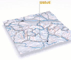 Places with similar names to Ivanje, Serbia and Montenegro ::
Disclaimer :: Information on this page comes without warranty of any kind |
||
|
Where is Ivanje? Elevation and coordinates ::
Latitude (lat): 43°20'33"N Longitude (lon): 20°28'31"E
Elevation (approx.): 983m (map arrows pan, magnifying glasses zoom) |
||
|
Visiting Ivanje? Hotel/Accommodation ::
Book a hotel in Ivanje Travel Guide ::
rental cars ::
car rental offers GPS waypoint ::
download a GPX waypoint (PoI) of Ivanje for your GPS receiver
|
||