|
search place name
|
||
Aït Baho (Essaouira, Morocco)Aït Baho is a town in the Essaouira region of Morocco. An overview map of the region around Aït Baho is displayed below.
regional and 3d topo map of Aït Baho, Morocco ::

Aït Baho airports ::
The nearest airport is AGA - Agadir Inezgane, located 92.8 km south of Aït Baho.
Other airports nearby include RAK - Marrakech Menara (154.9 km east), Nearby towns ::
Zaouit el Mehser (3.6km north west) //
Ifrane (3.7km north east) //
Ibellatn (3.7km north west) //
Id Hammou (5.6km south) //
Timessourine (5.3km north east) //
Imi nʼTlit (5.2km east) //
Aourir (7.6km south) //
Bachkad (7.3km south east) //
Aït Saïd (7.3km south east) //
Dar Caïd el Hajj Neknafi (8.4km north) //
Tazribine (8.8km south) //
Lahsene Abd el Kader (8.4km south east) //
Ed Dahr (9.2km south east) //
[all distances 'as the bird flies' and approximate] 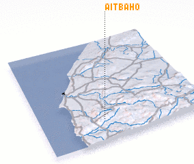 Places with similar names to Aït Baho, Morocco ::
// Ad Dabḩah (SY)
// Aït Baha (MA)
// Aït Bihi (MA)
// Aït Bouhou (MA)
// Aït Bouhou (MA)
// Aït Bohi (MA)
// Aït Ou Bohou (MA)
// Aït Baha (MA)
// Aït Baha (MA)
// Aït Bihi (MA)
Disclaimer :: Information on this page comes without warranty of any kind |
||
|
Where is Aït Baho? Elevation and coordinates ::
Latitude (lat): 31°13'0"N Longitude (lon): 9°36'0"W
Elevation (approx.): 493m (map arrows pan, magnifying glasses zoom) |
||
|
Visiting Aït Baho? Hotel/Accommodation ::
Book a hotel in Aït Baho Travel Guide ::
Buy a travel guide for Morocco rental cars ::
car rental offers GPS waypoint ::
download a GPX waypoint (PoI) of Aït Baho for your GPS receiver
|
||