|
search place name
|
||
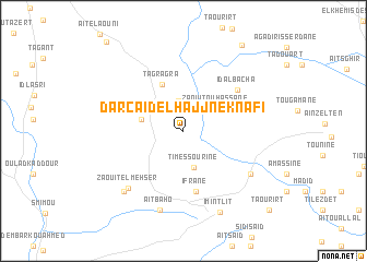
Dar Caïd el Hajj Neknafi (Essaouira, Morocco)Dar Caïd el Hajj Neknafi is a town in the Essaouira region of Morocco. An overview map of the region around Dar Caïd el Hajj Neknafi is displayed below.
regional and 3d topo map of Dar Caïd el Hajj Neknafi, Morocco ::
Dar Caïd el Hajj Neknafi airports ::
The nearest airport is AGA - Agadir Inezgane, located 100.7 km south of Dar Caïd el Hajj Neknafi.
Other airports nearby include RAK - Marrakech Menara (150.7 km east), Nearby towns ::
Dar Sidi Abd el Mjid (3.1km north) //
Timessourine (3.8km south) //
Zaouit Ou Hassane (3.6km north east) //
Tisrharine (3.8km west) //
Tagragra (5.2km north) //
Ifrane (6.3km south) //
Id al Bacha (6.3km north east) //
Zaouit el Mehser (7.5km south west) //
Aït el Cadi (7.3km south east) //
Aït Baho (8.4km south) //
Ibellatn (8.1km south west) //
Imi nʼTlit (8.9km south) //
Zaouia Moulay Lahsene (10.1km north east) //
Taourirt (11.0km south east) //
[all distances 'as the bird flies' and approximate] 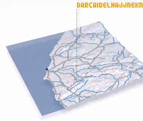 Places with similar names to Dar Caïd el Hajj Neknafi, Morocco :: Disclaimer :: Information on this page comes without warranty of any kind |
||
|
Where is Dar Caïd el Hajj Neknafi? Elevation and coordinates ::
Latitude (lat): 31°17'22"N Longitude (lon): 9°34'42"W
Elevation (approx.): 396m (map arrows pan, magnifying glasses zoom) |
||
|
Visiting Dar Caïd el Hajj Neknafi? Hotel/Accommodation ::
Book a hotel in Dar Caïd el Hajj Neknafi Travel Guide ::
Buy a travel guide for Morocco rental cars ::
car rental offers GPS waypoint ::
download a GPX waypoint (PoI) of Dar Caïd el Hajj Neknafi for your GPS receiver
|
||