|
search place name
|
||
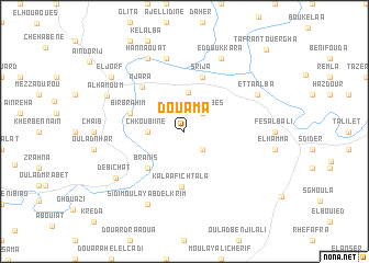
Douama (Taounate, Morocco)Douama is a town in the Taounate region of Morocco. An overview map of the region around Douama is displayed below.
regional and 3d topo map of Douama, Morocco ::
Douama airports ::
The nearest airport is FEZ - Fez Saiss, located 72.0 km south of Douama.
Other airports nearby include MEK - Meknes Bassatine (79.9 km south), TTU - Tetouan Saniat Rmel (116.4 km north), NNA - Kentira Kenitra (131.3 km west), AHU - Al Hociema Cherif El Idrissi (142.5 km north east), Nearby towns ::
Brhaoua (2.4km south east) //
Hajer Abbes (2.4km north east) //
Chkoubiine (3.1km west) //
Tasrout (3.9km north) //
Branis (4.8km south west) //
Kalaa Fichtala (5.7km south) //
Bir Brahim (4.9km west) //
Srija (5.8km north) //
Mjara (5.8km north west) //
Azzaba (7.6km north) //
Sidi Moulay Abd el Krim (8.0km south) //
Et Taalba (7.1km north east) //
Boukheïch (8.0km north) //
Ed Doukkara (8.0km north) //
Hannaouat (8.0km north) //
Debichat (7.4km south west) //
Al Hamoum (7.4km north west) //
El Jorf (8.3km north west) //
Tafrant Ouergha (10.8km north east) //
[all distances 'as the bird flies' and approximate] 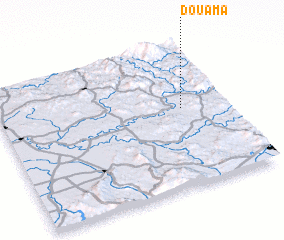 Places with similar names to Douama, Morocco ::
Disclaimer :: Information on this page comes without warranty of any kind |
||
|
Where is Douama? Elevation and coordinates ::
Latitude (lat): 34°33'0"N Longitude (lon): 5°12'0"W
Elevation (approx.): 141m (map arrows pan, magnifying glasses zoom) |
||
|
Visiting Douama? Hotel/Accommodation ::
Book a hotel in Douama Travel Guide ::
Buy a travel guide for Morocco rental cars ::
car rental offers GPS waypoint ::
download a GPX waypoint (PoI) of Douama for your GPS receiver
|
||