|
search place name
|
||
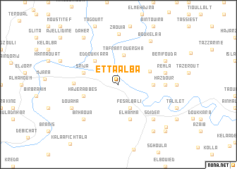
Et Taalba (Taounate, Morocco)Et Taalba is a town in the Taounate region of Morocco. An overview map of the region around Et Taalba is displayed below.
regional and 3d topo map of Et Taalba, Morocco ::
Et Taalba airports ::
The nearest airport is FEZ - Fez Saiss, located 74.2 km south of Et Taalba.
Other airports nearby include MEK - Meknes Bassatine (85.7 km south west), TTU - Tetouan Saniat Rmel (113.4 km north), AHU - Al Hociema Cherif El Idrissi (135.4 km north east), NNA - Kentira Kenitra (138.1 km west), Nearby towns ::
Fès al Bali (4.0km south) //
Tafrant Ouergha (4.7km north) //
Ed Doukkara (4.8km north west) //
Beni Kissane (4.6km north east) //
El Kaïtoun (4.6km east) //
El Hamma (5.8km south) //
Hajer Abbes (4.9km west) //
Srija (4.9km west) //
Tasrout (5.8km west) //
Hazdour (6.1km east) //
Remla (6.4km east) //
Brhaoua (7.2km south west) //
Sdider (7.2km south east) //
Zaouia (8.0km north) //
Beni Fouda (7.1km north east) //
Douama (7.1km south west) //
Bou Kelaa (8.1km north east) //
Dekioukiyene (8.7km south east) //
Daher (8.7km north west) //
Hannaoua (9.1km south east) //
Kouassem (9.6km south east) //
[all distances 'as the bird flies' and approximate] 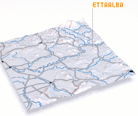 Places with similar names to Et Taalba, Morocco ::
Disclaimer :: Information on this page comes without warranty of any kind |
||
|
Where is Et Taalba? Elevation and coordinates ::
Latitude (lat): 34°35'0"N Longitude (lon): 5°8'0"W
Elevation (approx.): 144m (map arrows pan, magnifying glasses zoom) |
||
|
Visiting Et Taalba? Hotel/Accommodation ::
Book a hotel in Et Taalba Travel Guide ::
Buy a travel guide for Morocco rental cars ::
car rental offers GPS waypoint ::
download a GPX waypoint (PoI) of Et Taalba for your GPS receiver
|
||