|
search place name
|
||
Tafraout (Taroudannt, Morocco)Tafraout is a town in the Taroudannt region of Morocco. An overview map of the region around Tafraout is displayed below.
regional and 3d topo map of Tafraout, Morocco ::

Tafraout airports ::
The nearest airport is RAK - Marrakech Menara, located 115.9 km north of Tafraout.
Other airports nearby include AGA - Agadir Inezgane (123.3 km west), OZZ - Ouarzazate (137.3 km east), Nearby towns ::
Aït Moussa (1.9km south) //
Aït el Goumakh (1.9km south) //
Takaoucht (1.9km south) //
Irhir nʼOufella (1.6km west) //
Agadir nʼ Iznaguene (3.2km west) //
Taourirt (3.7km north east) //
Tassoumaat (4.0km north east) //
Zaouia nʼIgouramene (4.0km north east) //
Aït Guerri (4.8km west) //
Aït Ou Ali (5.8km south) //
Iachech (5.1km east) //
Sidi Saïd (5.1km east) //
Aït Ahmed (6.1km north east) //
Aït Jamaa (6.4km west) //
Sidi Bou Irezg (7.4km north) //
Iferkane nʼOufella (6.6km west) //
Ihbabene (7.6km north) //
Aït el Hajj (7.3km north west) //
Aït Yous (7.3km north west) //
Igoundaz (7.4km north east) //
Taddarine (8.1km south west) //
El Faïd (7.4km north east) //
Aït Harirou (8.1km north west) //
Tafellount (7.4km north west) //
Aferzaz (8.8km south east) //
Aït Hassaïn (8.5km north east) //
Tarzout (8.5km north west) //
Aït Abdallah (9.8km north east) //
NʼAïn (9.8km north west) //
[all distances 'as the bird flies' and approximate] 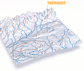 Places with similar names to Tafraout, Morocco ::
Disclaimer :: Information on this page comes without warranty of any kind |
||
|
Where is Tafraout? Elevation and coordinates ::
Latitude (lat): 30°35'0"N Longitude (lon): 8°17'0"W
Elevation (approx.): 595m (map arrows pan, magnifying glasses zoom) |
||
|
Visiting Tafraout? Hotel/Accommodation ::
Book a hotel in Tafraout Travel Guide ::
Buy a travel guide for Morocco rental cars ::
car rental offers GPS waypoint ::
download a GPX waypoint (PoI) of Tafraout for your GPS receiver
|
||