|
search place name
|
||
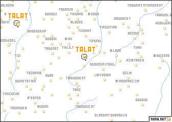
Talat (Taroudannt, Morocco)Talat is a town in the Taroudannt region of Morocco. An overview map of the region around Talat is displayed below.
regional and 3d topo map of Talat, Morocco ::
Talat airports ::
The nearest airport is AGA - Agadir Inezgane, located 121.9 km west of Talat.
Other airports nearby include OZZ - Ouarzazate (157.5 km north east), RAK - Marrakech Menara (159.8 km north), Nearby towns ::
Imiane (1.1km south) //
Ouzzoun (2.4km north east) //
Imi n Ou Arguioun (3.3km north east) //
Zaouia Aït Kourbane (3.6km south east) //
Tiferki (3.8km north east) //
Agouns nʼ Iyssil (3.7km south east) //
Tiklilt (3.7km north west) //
Arguioun (3.8km north east) //
Imiri (4.9km north west) //
Timguedert (5.2km south) //
Tizerht (5.6km north) //
Agouni Ougouram (5.8km south) //
Agadir Aguenousil (5.8km south) //
Aït Hsaïn (5.5km south east) //
Tassoult (5.3km west) //
Tazart (6.1km south west) //
Inejjarene (6.1km north west) //
Islane (5.8km east) //
Tililine (6.7km north) //
Afella Ouzaghar (6.4km east) //
Tadenst (6.6km west) //
Tamz (7.6km south) //
Alouss (7.6km north) //
Afergal (6.7km west) //
Tirguitine (7.7km north east) //
Tilioua (8.1km south west) //
Ifguiss (8.1km north west) //
Agouni (7.4km north west) //
Taourirt (7.4km north west) //
[all distances 'as the bird flies' and approximate] 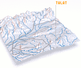 Places with similar names to Talat, Morocco ::
Disclaimer :: Information on this page comes without warranty of any kind |
||
|
Where is Talat? Elevation and coordinates ::
Latitude (lat): 30°11'0"N Longitude (lon): 8°18'0"W
Elevation (approx.): 1416m (map arrows pan, magnifying glasses zoom) |
||
|
Visiting Talat? Hotel/Accommodation ::
Book a hotel in Talat Travel Guide ::
Buy a travel guide for Morocco rental cars ::
car rental offers GPS waypoint ::
download a GPX waypoint (PoI) of Talat for your GPS receiver
|
||