|
search place name
|
||
Abut (Abra, Philippines)Abut is a town in the Abra region of Philippines. An overview map of the region around Abut is displayed below.
regional and 3d topo map of Abut, Philippines ::

Abut airports ::
The nearest airport is BAG - Baguio, located 147.8 km south of Abut.
Nearby towns ::
Abaquid (1.8km south west) //
Piducal (2.1km east) //
Nagaparan (2.2km north west) //
Bandi (2.3km west) //
Malabbaga (2.7km south east) //
Danglas (3.1km west) //
Cabaroan (3.1km west) //
Galao (3.1km west) //
Damulog (3.2km south west) //
Caupasan (3.4km south west) //
Domigiay (3.5km south) //
Lagayan (3.5km east) //
Buli (3.6km south east) //
La Paz (4.1km south) //
Toon (4.8km south) //
Padangitan (4.9km south) //
Pollot (4.8km north east) //
Namilagan (4.7km west) //
Pidipid (5.0km south) //
Pingaping (5.0km north east) //
Gaang (5.1km south east) //
Suli (5.4km south east) //
Cabcaborao (5.2km east) //
Canan (5.5km south) //
Baybaytin (5.5km north east) //
Sapday (5.6km south west) //
Calambat (6.1km north east) //
Lupa (6.0km east) //
Nangobongan (6.1km east) //
[all distances 'as the bird flies' and approximate] 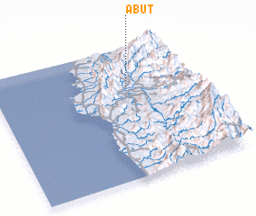 Places with similar names to Abut, Philippines ::
Disclaimer :: Information on this page comes without warranty of any kind |
||
|
Where is Abut? Elevation and coordinates ::
Latitude (lat): 17°42'35"N Longitude (lon): 120°40'37"E
Elevation (approx.): 115m (map arrows pan, magnifying glasses zoom) |
||
|
Visiting Abut? Hotel/Accommodation ::
Book a hotel in Abut Travel Guide ::
Buy a travel guide for Philippines rental cars ::
car rental offers GPS waypoint ::
download a GPX waypoint (PoI) of Abut for your GPS receiver
|
||