|
search place name
|
||
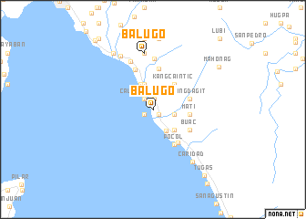
Balugo (Leyte, Philippines)Balugo is a town in the Leyte region of Philippines. An overview map of the region around Balugo is displayed below.
regional and 3d topo map of Balugo, Philippines ::
Balugo airports ::
The nearest airport is TAC - Tacloban Daniel Z Romualdez, located 51.1 km north east of Balugo.
Other airports nearby include NOP - Masbate Mactan Cebu Intl (102.6 km south west), BCD - Bacolod (196.6 km west), DGT - Dumaguete (231.2 km south west), Nearby towns ::
Wangag (0.9km south east) //
Palanas (0.9km south east) //
Borongo (1.3km south west) //
Tabgas (1.3km north) //
Calingatngan (1.7km north west) //
Cawilan (2.6km east) //
Damulaan (3.0km south east) //
Gungab (3.3km north) //
Albuera (3.5km north west) //
Cabatoan (3.5km south east) //
Kang Caintic (4.0km north east) //
Mati (4.4km east) //
Babalanga (4.4km east) //
Caningag (4.4km east) //
Kang Dagit (4.5km east) //
Pocol (5.0km south east) //
Tinagan (5.0km south east) //
Buac (5.0km south east) //
Naga (5.0km south east) //
Candonaya (5.1km north) //
Malitbog (5.3km north west) //
Libas (6.2km north) //
Siguinon (6.5km north west) //
Balugo (6.9km north) //
Talisayan (6.9km north) //
Binoljo (7.7km north west) //
Caridad (7.9km south east) //
Panalian (8.3km north west) //
Capatqan (8.7km north) //
[all distances 'as the bird flies' and approximate] 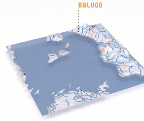 Places with similar names to Balugo, Philippines ::
Disclaimer :: Information on this page comes without warranty of any kind |
||
|
Where is Balugo? Elevation and coordinates ::
Latitude (lat): 10°53'18"N Longitude (lon): 124°42'37"E
Elevation (approx.): 11m (map arrows pan, magnifying glasses zoom) |
||
|
Visiting Balugo? Hotel/Accommodation ::
Book a hotel in Balugo Travel Guide ::
Buy a travel guide for Philippines rental cars ::
car rental offers GPS waypoint ::
download a GPX waypoint (PoI) of Balugo for your GPS receiver
|
||