|
search place name
|
||
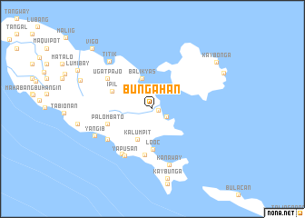
Bungahan (Mindoro Occidental, Philippines)Bungahan is a town in the Mindoro Occidental region of Philippines. An overview map of the region around Bungahan is displayed below.
regional and 3d topo map of Bungahan, Philippines ::
Bungahan airports ::
The nearest airport is MNL - Manila Ninoy Aquino Intl, located 116.8 km north east of Bungahan.
Nearby towns ::
Burol (0.8km east) //
Agkawayan (1.9km south east) //
Balikyas (4.0km north) //
Kalumpit (4.1km south west) //
Looc (5.0km south) //
Ipil (5.3km north west) //
Carcarit (5.7km south) //
Palombato (5.7km west) //
Yapusan (6.6km south west) //
Usiw (6.6km south west) //
Ugat Pajo (6.5km north west) //
Abibiray (6.6km south west) //
Liguayan (6.6km south west) //
Kanaway (7.1km south) //
Yangib (7.7km south west) //
Titik (7.8km north west) //
Kay Bunga (8.7km south) //
Nalimbayan (9.3km west) //
Kaybonga (9.6km north east) //
Ambil (9.6km north east) //
Vigo (10.3km north west) //
[all distances 'as the bird flies' and approximate] 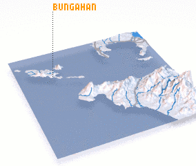 Places with similar names to Bungahan, Philippines ::
Disclaimer :: Information on this page comes without warranty of any kind |
||
|
Where is Bungahan? Elevation and coordinates ::
Latitude (lat): 13°46'0"N Longitude (lon): 120°15'0"E
Elevation (approx.): 10m (map arrows pan, magnifying glasses zoom) |
||
|
Visiting Bungahan? Hotel/Accommodation ::
Book a hotel in Bungahan Travel Guide ::
Buy a travel guide for Philippines rental cars ::
car rental offers GPS waypoint ::
download a GPX waypoint (PoI) of Bungahan for your GPS receiver
|
||