|
search place name
|
||
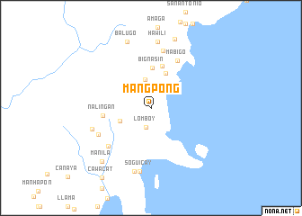
Mangpong (Mindoro Oriental, Philippines)Mangpong is a town in the Mindoro Oriental region of Philippines. An overview map of the region around Mangpong is displayed below.
regional and 3d topo map of Mangpong, Philippines ::
Mangpong airports ::
The nearest airport is KLO - Kalibo, located 135.3 km south east of Mangpong.
Other airports nearby include SJI - San Jose Antique (192.9 km south), ILO - Iloilo (227.4 km south east), BCD - Bacolod (258.9 km south east), Nearby towns ::
Lomboy (2.5km south) //
Colasi (3.1km north east) //
Wawan (3.6km north) //
Manaul (3.7km north east) //
Maliaw (4.0km south west) //
Langka (4.7km north east) //
Bignasin (4.9km north) //
Amuguis (5.4km north) //
Nalingan (5.9km west) //
Mabigo (6.7km north east) //
Palola (7.0km south west) //
Baong (7.3km north) //
Hinobigan (7.2km south west) //
Calatas (7.6km west) //
Soguicay (8.0km south) //
Calag (8.1km south) //
Hawili (8.2km north) //
Balugo (8.7km north) //
Manila (8.9km south west) //
Batobalawan (9.1km north) //
Cawacat (10.5km south west) //
[all distances 'as the bird flies' and approximate] 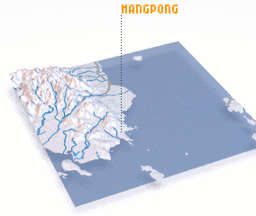 Places with similar names to Mangpong, Philippines ::
// Māngpung (MM)
// Möng Ping (MM)
// Möng Pang (MM)
// Möng Pang (MM)
// Mongpong (MM)
// Mangpong (PH)
// Monga-Upunga (CD)
// Muang Pang (LA)
// Muang Piang (LA)
// Mangpang (ID)
Disclaimer :: Information on this page comes without warranty of any kind |
||
|
Where is Mangpong? Elevation and coordinates ::
Latitude (lat): 12°25'35"N Longitude (lon): 121°23'34"E
Elevation (approx.): 255m (map arrows pan, magnifying glasses zoom) |
||
|
Visiting Mangpong? Hotel/Accommodation ::
Book a hotel in Mangpong Travel Guide ::
Buy a travel guide for Philippines rental cars ::
car rental offers GPS waypoint ::
download a GPX waypoint (PoI) of Mangpong for your GPS receiver
|
||