|
search place name
|
||
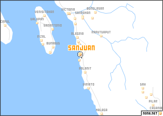
San Juan (Northern Samar, Philippines)San Juan is a town in the Northern Samar region of Philippines. An overview map of the region around San Juan is displayed below.
regional and 3d topo map of San Juan, Philippines ::
San Juan airports ::
The nearest airport is TAC - Tacloban Daniel Z Romualdez, located 145.6 km south east of San Juan.
Other airports nearby include KLO - Kalibo (226.3 km west), BCD - Bacolod (243.9 km south west), ILO - Iloilo (266.9 km south west), Nearby towns ::
Tugas (0.8km south west) //
Calagundi-an (3.2km north) //
Palanit (3.4km south) //
San Isidro (3.8km north) //
Alegria (4.9km north) //
Raputdaput (6.7km north east) //
Burabud (6.9km west) //
Viriato (7.2km south) //
Pilar (7.1km west) //
Erenas (8.0km north) //
San Antonio (9.2km north west) //
Manraya (9.3km west) //
[all distances 'as the bird flies' and approximate] 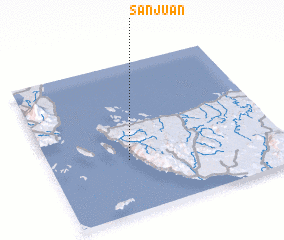 Places with similar names to San Juan, Philippines ::
Disclaimer :: Information on this page comes without warranty of any kind |
||
|
Where is San Juan? Elevation and coordinates ::
Latitude (lat): 12°21'17"N Longitude (lon): 124°20'18"E
Elevation (approx.): 65m (map arrows pan, magnifying glasses zoom) |
||
|
Visiting San Juan? Hotel/Accommodation ::
Book a hotel in San Juan Travel Guide ::
Buy a travel guide for Philippines rental cars ::
car rental offers GPS waypoint ::
download a GPX waypoint (PoI) of San Juan for your GPS receiver
|
||