|
search place name
|
||
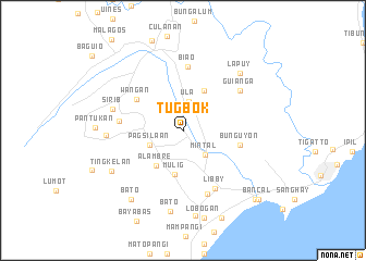
Tugbok (Davao, Philippines)Tugbok is a town in the Davao region of Philippines. An overview map of the region around Tugbok is displayed below.
regional and 3d topo map of Tugbok, Philippines ::
Tugbok airports ::
The nearest airport is CEB - Cebu Cotabato, located 140.6 km west of Tugbok.
Other airports nearby include CGY - Ladag Cagayan De Oro (173.1 km north west), Nearby towns ::
Ula (3.1km north) //
Mintal (3.3km south east) //
Pagsilaan (3.8km south west) //
Alambre (4.5km south west) //
Mulig (4.6km south) //
Upper Matina (4.6km north east) //
Wañgan (5.7km north west) //
Bunguyon (5.9km east) //
Biao (6.6km north) //
Tagakpan (6.6km west) //
Libby (6.7km south east) //
Bago (6.9km south) //
Guianga (7.0km north east) //
Sirib (7.5km west) //
Pagsiban (7.8km west) //
Lapuy (8.2km north east) //
Bato (8.3km south) //
Tingkelan (8.4km south west) //
Piedra (8.8km south) //
Bato (8.8km south west) //
Lobogan (9.1km south) //
Dumuy (9.7km south east) //
Talomo (10.1km south east) //
Bancal (10.3km south east) //
[all distances 'as the bird flies' and approximate] 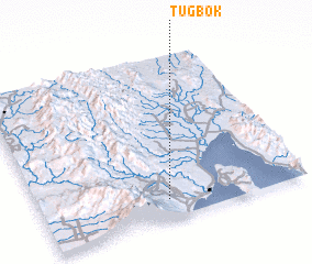 Places with similar names to Tugbok, Philippines ::
// Dagubek (PH)
// Dağbağ (TR)
// Dukubaka (GH)
// Digobuke (TZ)
// Dāki Baihk (PK)
// Doga Baihk (PK)
// Digabougou (ML)
// Dokabougou (ML)
// Dokobougou (ML)
// Tigabougou (ML)
Disclaimer :: Information on this page comes without warranty of any kind |
||
|
Where is Tugbok? Elevation and coordinates ::
Latitude (lat): 7°6'48"N Longitude (lon): 125°28'53"E
Elevation (approx.): 156m (map arrows pan, magnifying glasses zoom) |
||
|
Visiting Tugbok? Hotel/Accommodation ::
Book a hotel in Tugbok Travel Guide ::
Buy a travel guide for Philippines rental cars ::
car rental offers GPS waypoint ::
download a GPX waypoint (PoI) of Tugbok for your GPS receiver
|
||