|
search place name
|
||
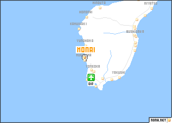
Monai (Hokkaidō, Japan)Monai is a town in the Hokkaidō region of Japan. An overview map of the region around Monai is displayed below.
regional and 3d topo map of Monai, Japan ::
Monai airports ::
The nearest airport is OIR - Okushiri, located 3.6 km south of Monai.
Other airports nearby include HKD - Hakodate (121.8 km east), AOJ - Aomori (185.3 km south east), SPK - Sapporo (196.1 km north east), MSJ - Misawa Ab (225.0 km south east), Nearby towns ::
Muenjima (0.3km north west) //
Senjō (2.0km south east) //
Yoneoka (2.5km south east) //
Yunohama (3.4km north) //
Toishi (3.9km south) //
Tomisato (4.6km south east) //
Aonae (5.6km south) //
Hamatsumae (5.8km south east) //
Hatsumatsumae (5.8km south east) //
Kamuiwaki (7.2km north) //
Yakushi (6.5km south east) //
[all distances 'as the bird flies' and approximate] 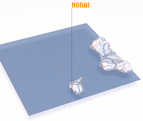 Places with similar names to Monai, Japan ::
Disclaimer :: Information on this page comes without warranty of any kind |
||
|
Where is Monai? Elevation and coordinates ::
Latitude (lat): 42°6'12"N Longitude (lon): 139°25'22"E
Elevation (approx.): -32768m (map arrows pan, magnifying glasses zoom) |
||
|
Visiting Monai? Hotel/Accommodation ::
Book a hotel in Monai Travel Guide ::
Buy a travel guide for Japan rental cars ::
car rental offers GPS waypoint ::
download a GPX waypoint (PoI) of Monai for your GPS receiver
|
||